Weather
The 2025 Tropical Storm Season
Here we are already!
As we approach the summer solstice, the thoughts are on getting back to watching the tropics. While the ‘peak’ of the (June-November) season doesn’t normally arrive for a couple more months, the potential threat has theoretically arrived already.
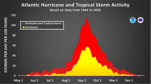
All is quiet for the moment….. So—now we wait to see who wants to be first to enter the "Gulf of America"….
/fl
Marksmanship
The M1 Garand

Named for its designer, John Garand, shown above,
Officially, it was known as 'U.S. Rifle, Caliber .30, M1'. Practically, it played a big role in the establishment of world peace and freedom.
General George S. Patton called it "the greatest battle implement ever devised.”

American Rifleman has an online tribute piece about the designer of this American icon. An interesting read that will add some nuance to our respectful remembrance this Memorial Day 2025. Have a safe one...
/fl
Marine Technology
Enter number of copies...
How long will it be until we get our next boat from a 3-D printer? According to a Delaware company that goes by the name of ErectorCraft, it’s a vision worthy of the cost of renting space in an office complex in Dover.
At ErectorCraft, we honor that tradition while embracing the next great leap in marine manufacturing: Large Format Additive Manufacturing (LFAM).
As the first large-scale 3D printing marine company in the United States, we combine time-honored craftsmanship with cutting-edge technology to revolutionize how boats, marine structures, and components are built.
Sometimes this stuff boggles the mind, but stranger things have come from Delaware…..We’ll see.
/fl
History
S.S. United States

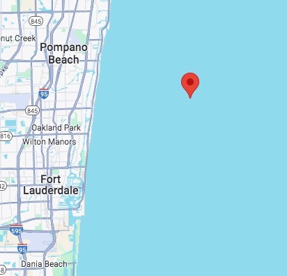
At 1318 CT today, the liner S.S. United States and her escort were about 6 miles off the Florida coast, headed South at about 4.3 knots. She’s making pretty good speed considering the proximity of the Gulf Stream current. She should be a magnificent sight for everyone along the coast today in the afternoon sunlight.
/fl
History
S.S. United States

The SS United States finally left her berth at Philly under tow last Wednesday, headed for Mobile, AL for 'pre-sinking' prep. Amazing, that after all these years tied up on the Delaware River, and a 'rust bucket', she still looks dignified under tow. I remember seeing her underway back in the 1960's during her glory years, crossing the Atlantic, while on active duty with USCG. Brings back memories seeing her passing under the Walt Whitman bridge; been across that bridge many times while stationed at Cape May, NJ.
"After nearly three decades moored along Philadelphia’s Delaware River, the historic ocean liner SS United States embarked on its final journey, February 19, 2025. Departing shortly before 1 p.m. ET, the legendary vessel is en route to Mobile, Alabama, where it will undergo preparations for its transformation into the world’s largest artificial reef off Florida’s Gulf Coast. The Wildwood Video Archive was on-board back in August. Check out those videos below. SS United States Ship Tour - • Exploring Inside the SS United States... SS United States Dock Drone Video - • Saying Goodbye SS United States - Dro... SS United States 360 Video - • SS United States VR Tour 2024 - 4K 36… "
Following her progress, at 1334 (CT) today, she was about 50 miles off the East coast of Florida, southbound at 5 knots.
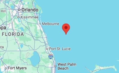
We’ll be following her progress, along with her interesting story.
/fl
Weather
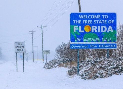
Greetings from “The Sunshine State”

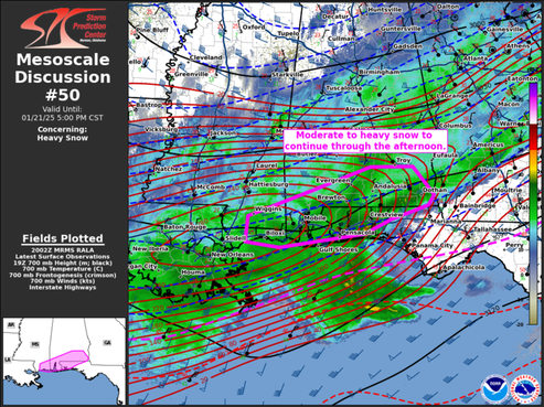
Mesoscale Discussion 0050 NWS
Storm Prediction Center Norman OK
0203 PM CST Tue Jan 21 2025
Areas affected...southern Mississippi...southern Alabama...and the western Florida Panhandle Concerning...Heavy snow Valid 212003Z - 212300Z
SUMMARY...Moderate to heavy snow will continue through the afternoon. DISCUSSION...A broad area of snow continues to shift east and northeast into portions of southern Alabama and the Florida Panhandle from Louisiana/southern Mississippi. Occasional sleet and freezing rain reports have occurred across the coast, but the main precipitation type has become snow area wide. Enhanced upper-level flow and 925-850 mb frontegenetic forcing are aiding in moderate to heavy snow production across these regions. Heavy snow observations have been reported from Gulfport, MS to Mobile, AL and into portions of southeastern Alabama over the last hour with visibility dropping to 1/4-1/2 mile. Guidance suggests snowfall rates may occasionally approach 1"/hr across southern Alabama near the Florida state line over the next 1-3 hours before tapering off later this evening as upper-level support shifts northward. ..Thornton.. 01/21/2025
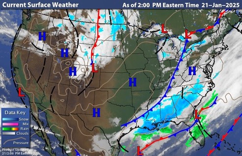
Snow Total Shatters 100+ Year Old Record
January 22, 2025
Pensacola absolutely shattered a snow total record that had stood for over 100 years.
Before Tuesday, Pensacola`s 24-hour snowfall record was 3 inches set in 1895.
By Tuesday night, the unofficial total at Pensacola was 7.6 inches. That also exceeded the all-time record for the most snowfall ever in Florida of 4 inches recorded near Milton. However, once the official totals are in, Milton may continue to hold the Florida record after receiving 8.8 inches.
It will take a few days to verify the snow totals and verify which city now holds the state record.
Across the rest of Escambia County, snowfall totals from 8-10 inches were reported across the area, including Molino, Bratt, Walnut Hill, McDavid and Cantonment. These totals however, are not official calibrated gauge and won’t be state records.
Source: https://www.northescambia.com/2025/01/snow-total-shatters-100-year-old-record
Tuesday, 21 January 2025. an unusual day indeed, that one!
/fl
Geography
What’s in a Name?
There is a proposal to rename this part of the Atlantic Ocean that we now call the Gulf of Mexico the Gulf of America. Since territorial portions of this referenced body of water are claimed by more than one American country, it seems ontologically sound and reasonable that the official name should reflect that fact—which inadvertently brings us to the questionable practice of referring to our beloved USA as “America.”
/fl
Weather
2024 Tropical Storm Threat
It’s Over…...

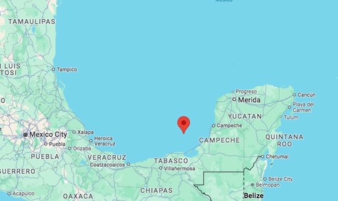
Remnants of SARA
Location: 19.5°N 91.9°W, Maximum Winds: 25 kt, Gusts: N/A Minimum Central Pressure: 1005 mb
/fl
Weather
99L / Sara
Still ticking, this system that has been lingering in the Caribbean for several days now is headed across the Yucatan, and into the Bay of Campeche. One of the model forecast (UKX2) has the system making landfall near here next Wednesday with a windspeed of 34 knots; I consider that to be unlikely since the other model’s show scattered tracks and a variety of wind speeds. We might know more when the system gets established in the Gulf of Mexico.
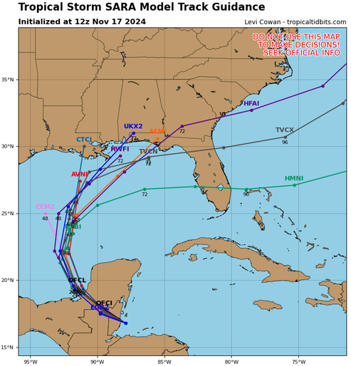
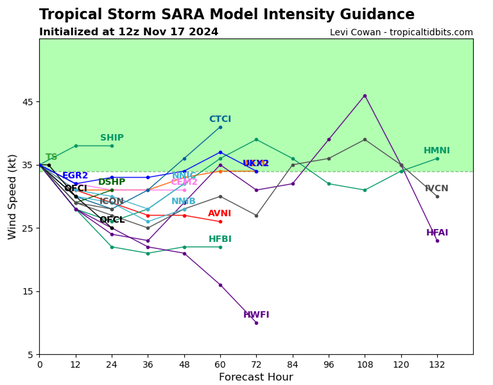
Watching.
/fl
Weather
99L AKA “Sara”
This system has become poorly structured and poorly organized. While some of the model track forecasts show it tracking toward the West coast of Florida, it will be a low-energy system—if it makes it that far.
Watching
/fl
