
Blog
Baseball
Historical Play
Catcher Danny Jansen had quite a ballgame the other night at Fenway in Boston.
He was behind the plate for the Red Sox when the team finished up a rain-delayed game from June with the Toronto Blue Jays. Jansen was at-bat when it started raining and the umps had to call the game.
What’s weird, though, is that Jansen was in a Blue Jays uniform at the time.
Let me explain: Between the rain delay and Monday night, he got traded from Toronto to Boston. And so became the first major leaguer ever to play for both teams … in the same game. Never happened before.
So, when he took the field for Boston in his new uniform, Jansen actually caught the strikeout of the player who pinch hit for him.
But his old team would have the last laugh: It was the former Blue Jay Jansen who struck out, ending the game for the Red Sox.
So who’s on first? is the wrong question: Who’s in the batter’s box and why’s he now behind the plate? That’s what we need to know.
It’s The World and Everything in It.
Weather
Hurricane Debby
What was TD 4 is now, or soon will be, Hurricane Debby as the storm moves toward landfall in the area of Florida's Big Bend, with forecast winds at 90mph producing a 6-10’ surge. Tornado watches extend as far east as St. Augustine.
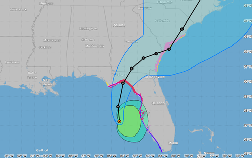
Debby will be moving over very warm waters and in a low-vertical shear environment prior to landfall. Therefore significant strengthening is likely through tonight, especially if the cyclone forms a well-defined inner core The official forecast is near the high side of the objective guidance and calls for the system to become a hurricane within 12 hours. The cyclone will weaken after it moves inland, but since the system will not be far from the coastline for the next few days, it is not predicted to fall below tropical storm strength through 72 hours. -NOAA
Stay safe.
/fl
Weather
Tropical Depression (TD) 4
TD 4 is departing the northern coast of Cuba and headed for the Big Bend area of Florida.
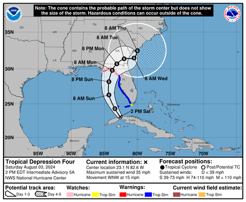
An high pressure area over the Gulf of Mexico is likely to keep the storm track over the eastern part of the Gulf. So far, the maximum windspeed forecast is a relatively low 60 knots, but that could change. We’ll be watching……
/fl