
Blog
Law and Order
Immigration Abuse
Immigration abuse has been going on in this country since shortly after the liberal interpretation of the 14th amendment, but it has recently become a big issue—a bellwether issue that has reached referendum status. The 14th amendment was not deigned to override our immigration law. A brief history lesson by Tucker Carlson recently explained this.
This brings to mind the following question. Since international maritime law accepts flags of registry as “home soil”, if a properly documented United States flagged vessel, while visiting a foreign port, shelters a foreign national from that host country who gives birth aboard said vessel while so sheltered, does the baby automatically become a United States citizen? Has there ever been a case where that has happened?
Liberalism creates some interesting dilemma's! This is why it is vitally important to have textualist’s on the high courts; someone capable of getting us back to the basics.
/fl
History
A nation founded on the principle’s of liberty, freedom, and individual responsibility.
The story of firearm innovation is inextricably tied to the story of the United States.
It was likely Colt himself who came up with the moniker “Peacemaker” for his gun. It was not merely a stab at irony or an adman’s clever copy. Colt often, and vigorously, argued that this gun could empower the average American. The average man could order one through the mail for the somewhat affordable price of $17 and have a light but powerful weapon within weeks. And selling his guns to civilians—every civilian, if possible—would be Colt’s principal goal.
The weapon could be brandished for self-protection, of course, but it was a firearm so formidable that war was to become too destructive to be worth engaging in, Colt argued. The gun was, to him, an imperative tool in fulfilling the American dream on both a personal and providential scale.
Sicut est hodie!
For patriotic American’s, the ideology remains the same today.
/fl
Baseball
Tale of Two Cities
OK, if you want to get technical, make it three cities.... Then forget Seattle.
The Houston Astros began their Major League Baseball life in 1962 as the Houston "Colt 45's", an expansion team in MLB's National League. Three years later, in 1965, thanks in part to our country's high-profile space program and the Houston Space Flight Center, the Colt 45's changed their name to the Houston "Astros” and moved into the then brand-new Houston "Astrodome". After 51 years of competition in MLB's National League, the Astros left the National League and joined the American League (West division) in 2013.
The Milwaukee Brewers club began their MLB life in 1969 in Seattle, Washington as the "Seattle Pilots", an expansion team in MLB's American League. After only one season in Seattle, the team moved to Milwaukee, Wisconsin and became the "Milwaukee Brewers." After 28 years competing in MLB's American League, the Brewers left the American League and joined the National League (Central division).
These two team's, the Houston Astros and the Milwaukee Brewers, as far as I know, are the only MLB franchises in history to switch leagues.
As I write this, they are competing for League Championship Pennant's in their respective league's. If both win their respective LCS, there will be something unique to add to the MLB "record book's" come opening day of the 2018 World Series.
It sure beats hurricanes and politics!
UPDATE: The league-swapper's won’t be meeting each other this year in the World Series. It’l be the Red Sox v. the Dodgers.
/fl
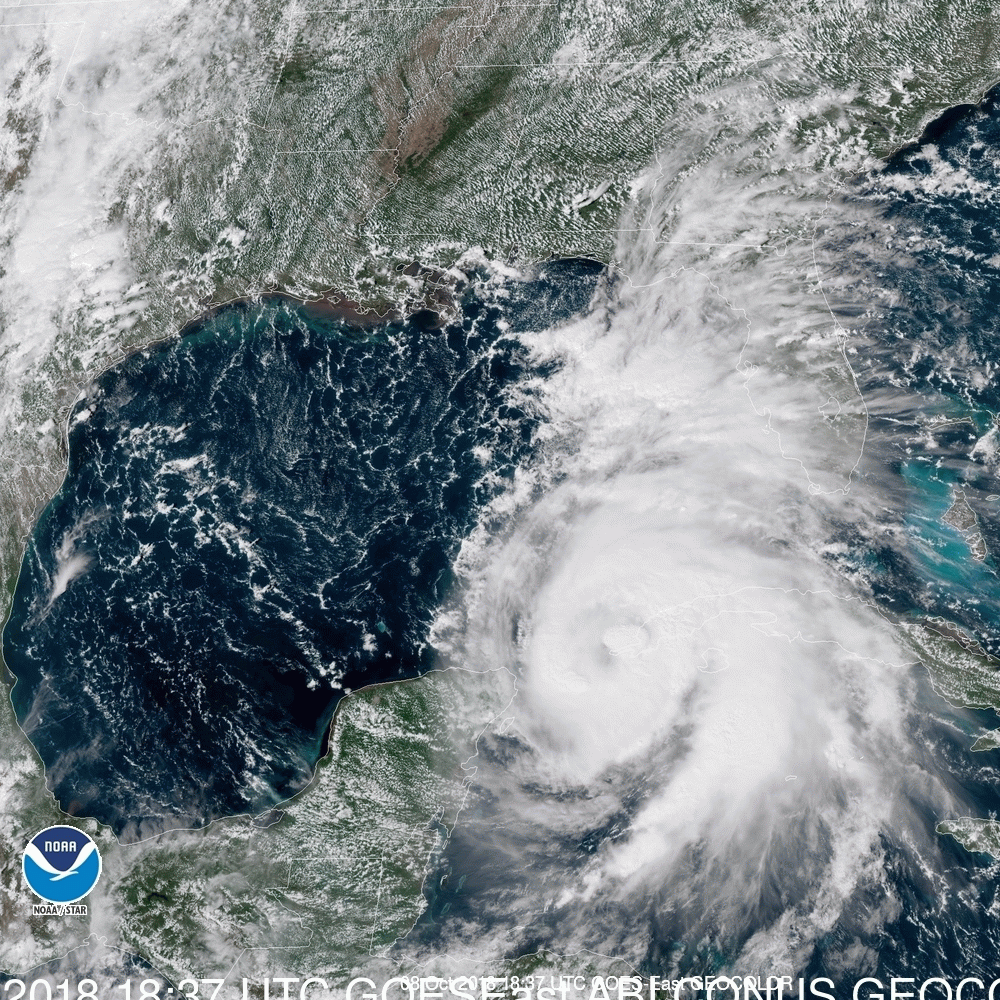
Weather: Hurricane Michael
And Now: The Cleanup
Here is a sampling of what people miss when they follow evacuation orders:
Hurricane Michael made landfall at 2 pm EDT October 10, 2018 near Mexico Beach, FL with top sustained winds of 155 mph and a central pressure of 919 mb. This makes Michael the strongest landfalling mainland U.S. hurricane (by pressure) since Camille of 1969, which had a 900 mb pressure, and the strongest by wind speed since Hurricane Andrew of 1992, which had 165 mph winds. Note that Hurricane Maria of 2017 hit Puerto Rico with winds of 155 mph and a central pressure of 920 mb, and was virtually identical in intensity to Michael.
The question was “is this going to be a history maker?”
And the answer is “yes.”
It should be pointed out, and this storm is a good example, that the confidence level regarding track is higher than the confidence level regarding intensity. The forecast track of Michael was amazingly precise as far back as 0400CDT on Tuesday. It was the rapid increase in intensity that left everyone in awe; and that is why it’s foolish to ride one of these things out when given the opportunity, and plenty of time, to move out of the way.
/fl
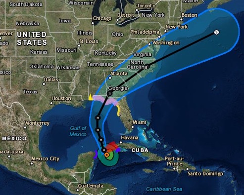
Weather
Hurricane Michael
If Michael reaches the coast with top winds of at least 130 mph (minimal Category 4 strength), it will be the strongest hurricane landfall ever recorded in the Florida Panhandle, as well as along most of Florida's Gulf Coast—all the way from the Alabama border to Punta Gorda—in records going back to 1851.
This isn’t going to be like past western FL panhandle/AL majors like Dennis, Ivan, Opal, Eloise. And it’s not like Hermine, Kate farther east but weaker. #Michael will make new history for central Panhandle, Big Bend. Some of you could get water and wind worse than ever before. pic.twitter.com/5b4AV1c7QR
— Dr. Rick Knabb (@DrRickKnabb) October 10, 2018
Michael has been adhering closely to the general course predicted by our top track models. With steering currents solidly in place, there is no reason to expect Michael to greatly depart from a northward track that will start to bend to the north-northeast around or just before landfall. Model guidance is clustered tightly near the center of the NHC forecast cone.
… and the NHC shows the center to be headed toward Tyndall Air Force Base near Panama City, arriving around 1-2 PM today (Wednesday October 10)
/fl
Weather
Hurricane Michael
Previous data remains valid. “There is little change."
Hurricane Michael Discussion Number 11 NWS National Hurricane Center Miami FL AL142018 400 AM CDT Tue Oct 09 2018
Reports from an Air Force Reserve Hurricane Hunter aircraft a few hours ago indicate that Michael's strengthening has paused, with the maximum winds near 80 kt and a central pressure near 973 mb. The aircraft also reported that the eyewall had become less organized, which may be due to some dry air entrainment and shear….. There is little change….
At the moment, the center of Hurricane Michael is expected to make landfall in the vicinity of Mexico Beach (between Panama City and Port St. Joe) Wednesday, early afternoon, with winds around 120 mph.
The wind in Pensacola is forecast to be out of the NNE and slowly backing Wednesday morning, with wind speed building to around 34 mph, and occasional gusts as high as 48 mph as Michael comes ashore in the Eastern panhandle.
Monitoring.
/fl
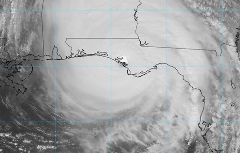
Weather
Hurricane Michael
As of 1600 CDT today, an eye has started to develop. Central pressure is currently 978 mb. The forecast track has shifted slightly to the West. Currently, the storm is forecast to come ashore in the area of Port St. Joe at around 1300 Wednesday as a major hurricane (wind speed in excess of 110 mph.)
Monitoring….
/fl
Weather
Tropical Storm (soon to become Hurricane) Michael
In keeping with past cases, the forecast storm track has remained fairly steady, but the intensity potential is still in doubt.
NWS National Hurricane Center Miami FL AL142018 400 AM CDT Mon Oct 08 2018
Michael has become better organized this morning, with the deep convection migrating westward on top of the low-level center and upper-level outflow beginning to increase within the western semicircle. An Air Force Reserve Hurricane Hunter aircraft made several passes through the system during the past few hours, and somewhat surprisingly, found that the central pressure has fallen to about 983 mb and maximum winds have increased to near 60 kt. This increase in intensity indicates that despite the shear which has been affecting Michael, the system has, by definition, rapidly intensified during the past 24 hours. With the increase in the initial wind speeds, the official intensity forecast is higher than in the previous forecast. Decreasing vertical shear and very warm sea surface temperatures are expected to support continued strengthening, and due to the favorable conditions, the NHC intensity forecast follows a blend of the IVCN consensus and the HCCA model. This new official forecast brings the intensity to just below major hurricane strength in 48 hours, and since the storm will still be over water for a time between 48 and 72 hours, there is a real possibility that Michael will strengthen to a major hurricane before landfall...
The current forecast for Pensacola shows storm force winds probably arriving Wednesday morning, with surface wind building to around 25 mph, with 37 mph gusts, by 0700 Wednesday. That could change though.
/fl
Weather
Tropical Depression Fourteen
NWS National Hurricane Center Miami FL AL142018 1000 AM CDT Sun Oct 07 2018
Satellite and radar data indicate that the depression continues to become better organized...The depression appears to be close to tropical storm strength and Dvorak estimates from TAFB and SAB are between 30-35 kt. An Air Force Reserve reconnaissance aircraft is scheduled to investigate the system early this afternoon and should provide a better assessment of the intensity of the cyclone….warm waters, should allow for gradual strengthening as the system moves northward over the Gulf of Mexico. Nearly all of the intensity models bring the cyclone to hurricane strength over the Gulf of Mexico in 2 to 3 days...The depression is moving northward at about 5 kt. The system is forecast to move generally northward during the next 2 to 3 days, with some increase in forward speed as it moves between a deep-layer ridge over the western Atlantic and a trough over the west-central United Sates. A northeastward turn is expected after 72 hours...
Hopefully this thing will keep moving and not slow down and intensify over the GOM. At the present time, we are forecast to be off the port bow of the center when it comes ashore. We’ll learn a lot more important stuff about this storm (track and intensity) within the next 24 hours.
/fl
Culture
The effect of Fake News and Junk Science
Brett Kavanaugh and George Zimmerman might be considered to be near opposite ends of a social spectrum, but they share something in common. Something profound and important. Both Kavanaugh and Zimmerman have had their lives altered by a false narrative and the vindictive manipulation of our so-called "system." They are both victims of what has become known as a "grievance industry."
How many more victims are there? What role's do "fake news" and "junk science" play in the grievance industry? That last question is addressed today by Albert Mohler in his Daily Briefing for October 4, 2018.
/fl