
Tropical Depression Fourteen
NWS National Hurricane Center Miami FL AL142018 1000 AM CDT Sun Oct 07 2018
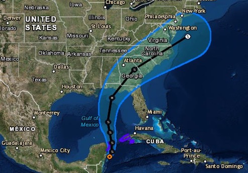
Satellite and radar data indicate that the depression continues to become better organized...The depression appears to be close to tropical storm strength and Dvorak estimates from TAFB and SAB are between 30-35 kt. An Air Force Reserve reconnaissance aircraft is scheduled to investigate the system early this afternoon and should provide a better assessment of the intensity of the cyclone….warm waters, should allow for gradual strengthening as the system moves northward over the Gulf of Mexico. Nearly all of the intensity models bring the cyclone to hurricane strength over the Gulf of Mexico in 2 to 3 days...The depression is moving northward at about 5 kt. The system is forecast to move generally northward during the next 2 to 3 days, with some increase in forward speed as it moves between a deep-layer ridge over the western Atlantic and a trough over the west-central United Sates. A northeastward turn is expected after 72 hours...
Hopefully this thing will keep moving and not slow down and intensify over the GOM. At the present time, we are forecast to be off the port bow of the center when it comes ashore. We’ll learn a lot more important stuff about this storm (track and intensity) within the next 24 hours.
/fl