
Blog
Weather
2024 Tropical Storm Threat
It’s Over…...

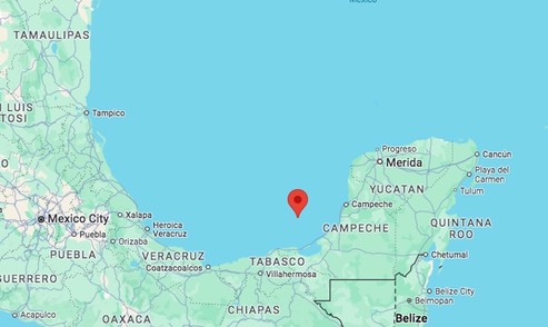
Remnants of SARA
Location: 19.5°N 91.9°W, Maximum Winds: 25 kt, Gusts: N/A Minimum Central Pressure: 1005 mb
/fl
Weather
99L / Sara
Still ticking, this system that has been lingering in the Caribbean for several days now is headed across the Yucatan, and into the Bay of Campeche. One of the model forecast (UKX2) has the system making landfall near here next Wednesday with a windspeed of 34 knots; I consider that to be unlikely since the other model’s show scattered tracks and a variety of wind speeds. We might know more when the system gets established in the Gulf of Mexico.
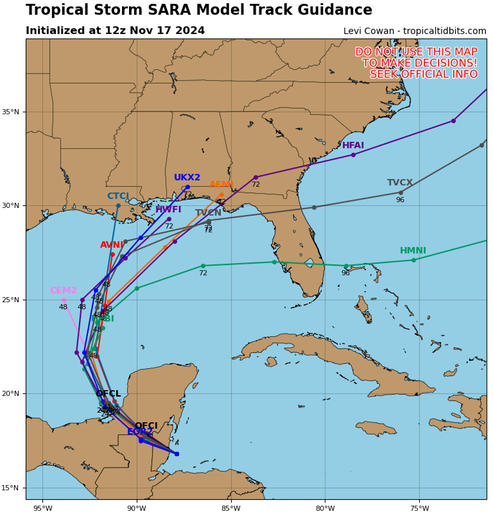
Watching.
/fl
Weather
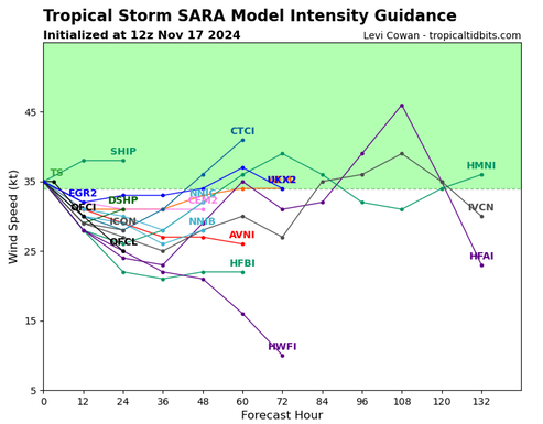
99L AKA “Sara”
This system has become poorly structured and poorly organized. While some of the model track forecasts show it tracking toward the West coast of Florida, it will be a low-energy system—if it makes it that far.
Watching
/fl
Weather
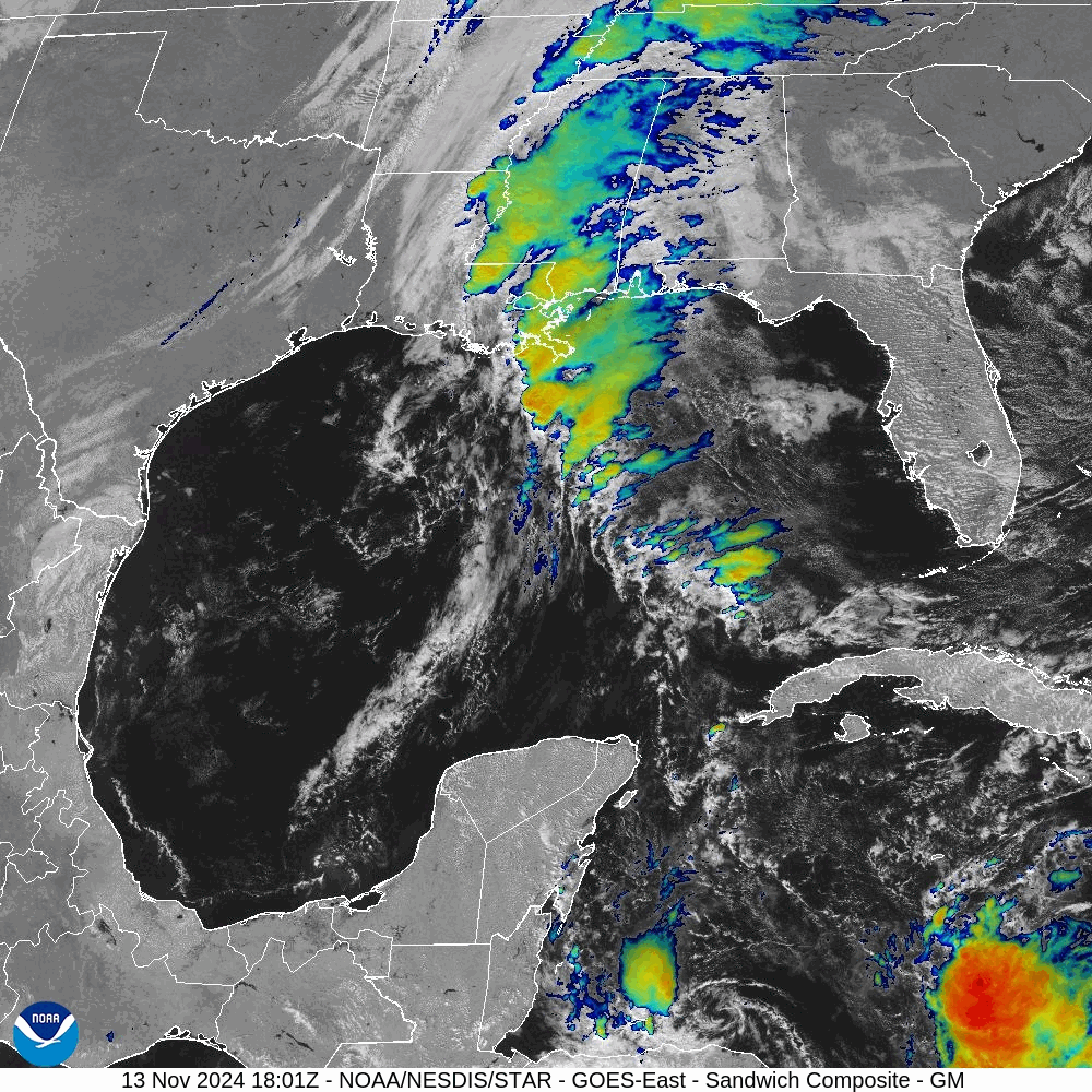
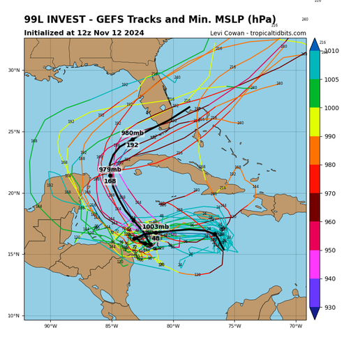
Genesis of 99L
The tropical system labeled 99L can be seen forming in the lower right of this satellite photo-series; the CCW banding is clearly visible in the following image:
Here is what the ECMWF (European Centre for Medium-Range Weather Forecasts) is forecasting for this system:
Here is what the National Hurricane Center has to say, currently, about this system/
[T]he system is expected to become a tropical storm within the next day or so and it is likely to bring tropical storm or hurricane conditions to land areas within the next 36 to 48 hours. Therefore, the National Hurricane Center is initiating Potential Tropical Cyclone advisories for this disturbance. The initial motion is more uncertain than normal since the system is still in the formative stage, but the best estimate is westward at about 5 kt.
Once the system becomes better organized and develops an inner core, the environmental conditions appear favorable for strengthening. Thus, the NHC forecast shows strengthening while the system moves into the western Caribbean sea.
The system is forecast to approach Belize and the Yucatan Peninsula of Mexico at or near hurricane strength by early next week where there is a risk of dangerous storm surge and damaging winds.
It is too soon to determine what impacts the system could bring to portions of the eastern Gulf of Mexico, including Florida, the Florida Keys, and Cuba during the middle portion of next week. Residents in these areas should regularly monitor updates to the forecast.
NOAA/NHC
Watching.
/fl
Weather
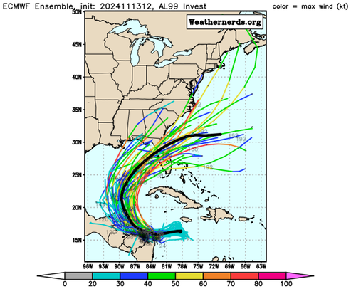
Invest 99L
We’re still not out of the woods as far as the 2024 Tropical Storm Season is concerned.
We’re eyeballing a low pressure area south of Jamaica that several of the model’s predict will eventually turn into a hurricane—with a track that hooks around the Western end of Cuba and makes landfall on the West coast of Florida sometime around 20 November.
Remembering what the renowned philosopher Lorenzo Pietro Berra said, "It ain’t over til' it’s over."
Watching...
/fl
Firearms
Taurus 22 TUC
From Taurus USA, an interesting new variation of the venerable Beretta Bobcat.

The video oration is in error regarding the magazine capacity of this piece; the correct capacity is 9+1.
The only two advantages that I see that this has over the Beretta is maybe the sights, and certainly the MSRP. I’m a big fan of thumb safeties on pistols; I know, this thing is DAO, but it’s more than a belt and suspenders thing—over the years with me, working the thumb safety has become an unconscious part of the presentation.
/fl
Weather
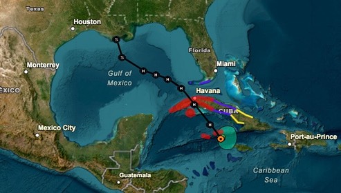
Rafael Update
There is now a question whether Rafael will make it past the center of the Gulf of Mexico, or will it slowly dissipate at sea?
Rafael will become a major hurricane before it makes landfall in western Cuba later today. Some weakening is forecast when the storm crosses Cuba, but Rafael is likely to remain a hurricane over the southeastern and southern Gulf of Mexico during the next few days. After that time, increasing southwesterly shear and significantly drier air are likely to result in weakening, however a more southerly track over the Gulf could result in less hostile conditions, and there is larger-than-normal uncertainty regarding Rafael's intensity later in the forecast period. The hurricane is moving northwestward or 320/11 kt. Rafael should continue to move around the southwestern side of a mid-level high pressure ridge over the southwestern Atlantic. The ridge is forecast to build westward over the eastern Gulf of Mexico during the next couple of days which is expected to cause Rafael to turn more westward over the southern Gulf of Mexico. The track guidance is in good agreement for the first 48 to 60 h, but there is increasing spread after that time. Much of the guidance now suggests that the ridge will remain to the north of the system through much of the forecast period. This has resulted in a southward shift in the model envelope and the updated NHC track forecast has been shifted in that direction after 72 hours. The new forecast lies north of the latest consensus aids and additional southward adjustments may be needed in subsequent forecasts.
NOAA/NWS
Watching.
/fl
Weather
Rafael
Here we are in the last month of the 2024 Tropical Storm Season and all eyes are still on the tropics.
At this time, it looks like Rafael is headed toward Houma, LA, and will make landfall sometime around the 10th of November with winds forecast to be around 40 mph. If the forecast is correct, it should bring some much needed rain and little damage…
Watching.
/fl