
Blog
Weather
Dorian
Is it the wind that I hear? Or, is that a collective sigh of relief coming from the East Coast of Florida?
A reason to rejoice. In hurricanes, as in war, the difference between a near-miss and a direct hit can be the difference between life and death.
Florida is not out of the woods yet. The way that this storm has been acting leaves room for bewilderment, along with the reality that there are more people still in its path.
/fl
Weather
Dorian
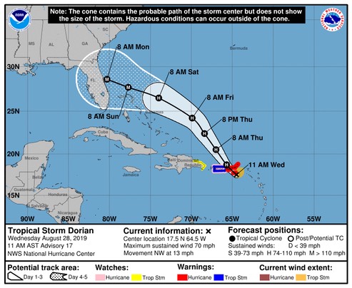
WIND: Hurricane conditions are possible in the northwestern Bahamas by Sunday, with tropical storm conditions possible by Saturday night or Sunday morning.
STORM SURGE: A life-threatening storm surge will raise water levels by as much as 10 to 15 feet above normal tide levels in areas of onshore winds in the northwestern Bahamas. Near the coast, the surge will be accompanied by large and destructive waves.
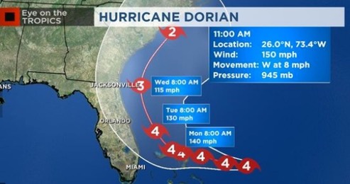
At this moment, tropical storm force winds from Dorian are forecast to arrive on the East coast of Florida Sunday, with the center of the hurricane coming ashore the following day somewhere near West Palm Beach, with winds around 140 mph. There have been variations in both track and speed; exact figures are uncertain. One thing that is certain though: Dorian is a very dangerous storm.
/fl
Weather
Dorian
All indications are that by this Labor Day weekend, a powerful hurricane will be near the Florida or southeastern coast of the United States.
We’re looking at forecasted wind speed in excess of 110 mph when Dorian comes ashore next Monday. It could be much greater than that; let’s hope not.
/fl
Weather
Dorian
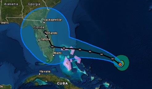
At this writing, Dorian is forecast to come ashore as a tropical storm (39-73 mph winds) along the East coast of the Florida peninsula sometime around 0800 Sunday. But, just how accurate is that forecast?
Users are reminded not to focus on the details of the extended track forecast as the average 5-day track error is around 200 miles.
Dry air continues to plague Dorian, and interaction with the mountainous terrain of St. Lucia will likely hinder significant development in the short term. However, the models continue to indicate that the upper-level flow pattern and shear conditions are expected to remain favorable for strengthening throughout the forecast period, so it is uncertain why the dynamical models are not showing more development and strengthening when compared to the more robust statistical SHIPS intensity models, especially at days 4 and 5 when Dorian will be moving over SSTs greater than 29 deg C and into a fairly moist environment. For now, the official intensity forecast remains basically midway between the stronger SHIPS model and the much weaker global and regional models. Given the large spread in the guidance, there is lower than normal confidence in the intensity forecast, especially on days 4 an 5.
Just what will happen when Dorian gets over the Gulf Stream? This is a tricky one!
/fl
Seamanship
Security Afloat
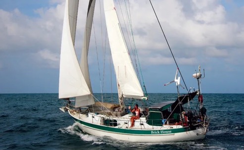
As cruisers, we generally anchor where nature gives us the best protection from wind and waves, not from humans. The human element is far more unpredictable than any weather forecast…. To 90 percent of the world, most sailboats, even our 43-year-old, cosmetically challenged Valiant 40, are “treasure ships” when the anchor is dropped….the simple act of hanging our laundry out to dry can demonstrate just how much we have compared to the local who feels lucky to have only an old T-shirt and a patched pair of britches.
Here, Patrick and Rebecca Childress take the non-lethal approach to repelling boarder’s; an approach that, history shows us, will not always work.
Opinion’s regarding the carrying of firearms on cruising yachts are just as polarized offshore as they are onshore. Many sailor’s put a lot of thought and planning into their itinerary and provisioning, but put very little thought into the potential security threats that they are bound to encounter while underway. Security should be a part of your trip plan.
Some reasonably up-to-date information regarding world-wide cruising ground security can be found at the Noonsite website.
A variety of useful Youtube video’s from Patrick and Rebecca Childress can be found here.
Semper Paratus.
/fl
Weather
Dorian
The time of year has arrived when everyone around here gets restless about tropical storms.
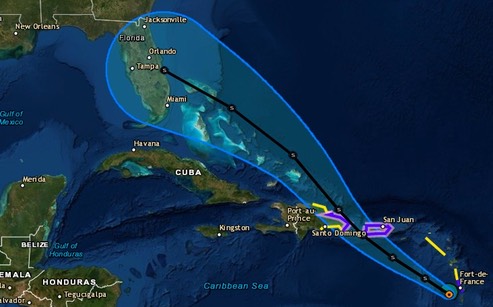
This is one to keep a close eye on; it’s early, but right now it’s headed for the Old Bahama Channel, on a course that will put it into the Gulf of Mexico.
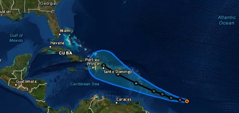
An ASCAT-B overpass at 0024 UTC revealed that Dorian is moving slightly faster than previously estimated, now 280/12 kt. Unlike the intensity guidance, the track models are in quite good agreement on the track of Dorian. The tropical storm should continue moving westward to west-northwestward at a similar forward speed, steered primarily by a mid-level ridge stretching across most of the central Atlantic. The NHC forecast is nearly on top of the previous advisory and remains very near the TVCN and HCCA consensus aids.
/fl
Weather
Thunderstorms
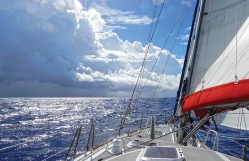
There’s a fabulous line from an old Paul Simon song that I often sing to myself while sailing: I can gather all the news I need from the weather report. It is part of the magic of sailing, this ancient process by which we propel our vehicles through and with the environment that surrounds them.
The awesome beauty of a thunderstorm is one of the many things that make sailing so enchanting. But, only a fool would not give them the respect that they deserve.
Here, Charles Doane writes about “decision time” when we see one of these phenomena approaching.
/fl