
Blog
Weather
Hurricane Ian
The forecast track of Hurricane Ian has shifted further East; back to where it was located earlier. No matter where this thing goes ashore, it’s going to inflict some catastrophic storm surge—in addition to the tornadoes that reside off the starboard bow of all hurricanes.
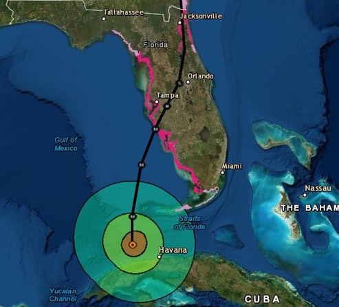
A large number of the resident’s of Southwest Florida will likely be spending this winter on a Bobcat. Hopefully, all evacuation plans have been activated and there are no cases of gridlock that prevent an safe and orderly outflow of residents.
/fl
Weather
Ian Uncertainty
If there is anything certain about tropical storms, it’s the uncertainty of trying to guess where they are going. The current official NHC track forecast has shifted slightly to the west, however the AEMI Model (Global Ensemble Forecast System), which was one of the high performing models in 2021, show the forecast track of the storm making landfall in the area of Navarre, Florida. That’s getting awfully close to home…
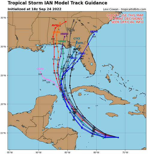
Still watching closely….
/fl
Weather
Tropical Storm Ian
TD 9 is now Tropical Storm 'Ian.'
At 0700 CDT, Tropical Storm Ian was located near 14.2N 74.5W, with winds around 45 mph, moving WSW at 15 mph. The current forecast has the system’s track arcing clockwise toward the North, reaching hurricane status by Monday morning, crossing Cuba and reaching the Gulf of Mexico sometime Tuesday morning where the forecast predicts it will become a major hurricane, continuing its clockwise arc until making landfall South of Tampa Bay late Wednesday night or early Thursday morning.
These forecasts appear to be getting more precise as the technology improves, but we should remember that the track shown on the forecast is a consensus estimate with a cone of uncertainty that, at the present time, extends from Mexico Beach to Miami—and beyond.
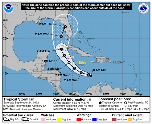
I expect to see refugees starting to arrive in the Pensacola area along with out-of-state utility company trucks staging along I-10 any time now. Hopefully, everyone in the path of this thing will be safe and ready,
Watching closely.
/fl
Weather
Invest 98L; now Tropical Depression 9
Still slow to develop, the forecast for this system is not good news for Florida. The current forecast shows the, yet unnamed, storm going ashore in the southwestern part of the Florida peninsula next Wednesday morning as a major hurricane with winds in excess of 95 knots.
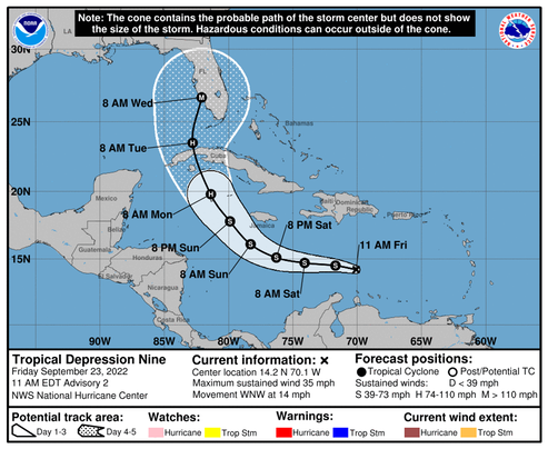
Watching closely...
/fl
Weather
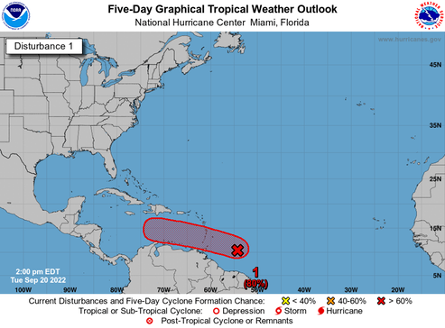
98L
Invest 98L has been fairly slow to develop, but that status could change very quickly, It is currently located near 12.3°N 66.3°W and moving in a Westerly direction, with a central pressure of 1006 mb, and winds around 30 knots.
AMZ001-230915- Synopsis for Caribbean Sea and Tropical N Atlantic from 07N to 19N between 55W and 64W 504 PM EDT Thu Sep 22 2022 .
SYNOPSIS...A tropical wave is over the eastern Caribbean with axis near 66W. A low pressure of 1006 mb is analyzed along the wave axis near 12N66W. The environment is forecast to become more conducive for development, and a tropical depression is likely to form in the next day or so. The low is forecast to move west- northwestward and be over the central Caribbean Sea this weekend where conditions are expected to be conducive for additional development. Locally heavy rainfall and gusty winds are likely to affect the Windward Islands, northern Venezuela, and the ABC island chain today. These impacts are likely to spread to northeastern Colombia later this evening. Interests in Jamaica should closely monitor the progress of this system.
The forecast models show the system entering the Gulf of Mexico by next Tuesday, 27 Sep.
Watching closely…
/fl
Weather
One to Watch
There is a "tropical wave” (“98L") disturbance presently located near 10N, 55W, with an 80% chance of development, that the GFS modeling predicts will be entering the Gulf of Mexico between Cuba and Mexico in about 8 days.
It’s still a long way off, but the intensity models indicate that system has the potential for Category 2 or 3 hurricane status—or even higher by next week at this time.
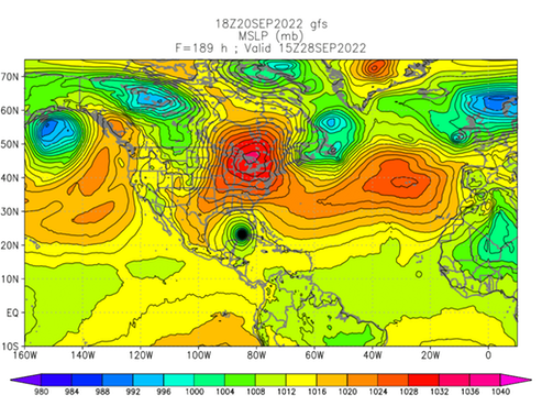
Not good news...
Watching closely.
/fl
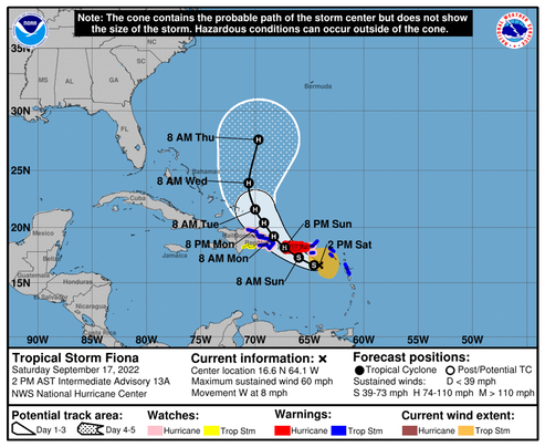
Weather
Hurricane Fiona
It looks like Hurricane Fiona is probably headed for Bermuda as a Major.
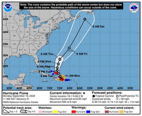
May be a good time for those folks to make reservations for a table at the Gunpowder Tavern—if it’s still open?
/fl
Weather
Tropical Storm, soon to be Hurricane FIONA
I always get a little nervous when these things get near the Old Bahama Channel, but the forecast calls for Fiona’s track to turn north before it crosses 73°W. We’ll see…..
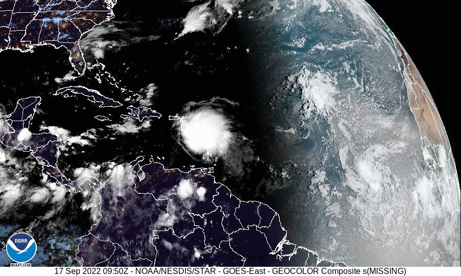
Watching...
/fl
Weather: Storm Ready Resources
AKC Pet Disaster Relief Program
The American Kennel Club (AKC) Program
AKC Reunite, AKC Clubs, private organizations and pet lovers are working together to help ensure we never again see a pet perched on a rooftop, or swimming through floodwaters, or even worse. We’re working toward accomplishing that goal donating AKC Pet Disaster Relief trailers to local Emergency Management teams across the country. All donations from AKC Clubs, private organizations and pet lovers are tax deductible through AKC Reunite.
/AKC Reunite