
Tropical Storm Ian
TD 9 is now Tropical Storm 'Ian.'
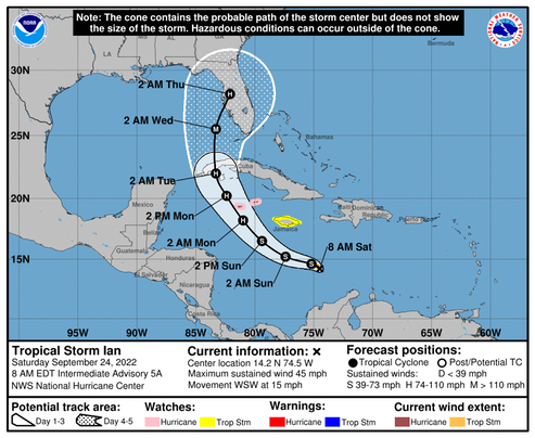
At 0700 CDT, Tropical Storm Ian was located near 14.2N 74.5W, with winds around 45 mph, moving WSW at 15 mph. The current forecast has the system’s track arcing clockwise toward the North, reaching hurricane status by Monday morning, crossing Cuba and reaching the Gulf of Mexico sometime Tuesday morning where the forecast predicts it will become a major hurricane, continuing its clockwise arc until making landfall South of Tampa Bay late Wednesday night or early Thursday morning.
These forecasts appear to be getting more precise as the technology improves, but we should remember that the track shown on the forecast is a consensus estimate with a cone of uncertainty that, at the present time, extends from Mexico Beach to Miami—and beyond.
I expect to see refugees starting to arrive in the Pensacola area along with out-of-state utility company trucks staging along I-10 any time now. Hopefully, everyone in the path of this thing will be safe and ready,
Watching closely.
/fl