
Blog
Weather
Hurricane Ida Update
Ida has a well-developed eye and is bearing down on the coast of Louisiana at 14 knots, with a windspeed (at 1600CDT) of 90 knots. The forecast predicts further strengthening prior to landfall.
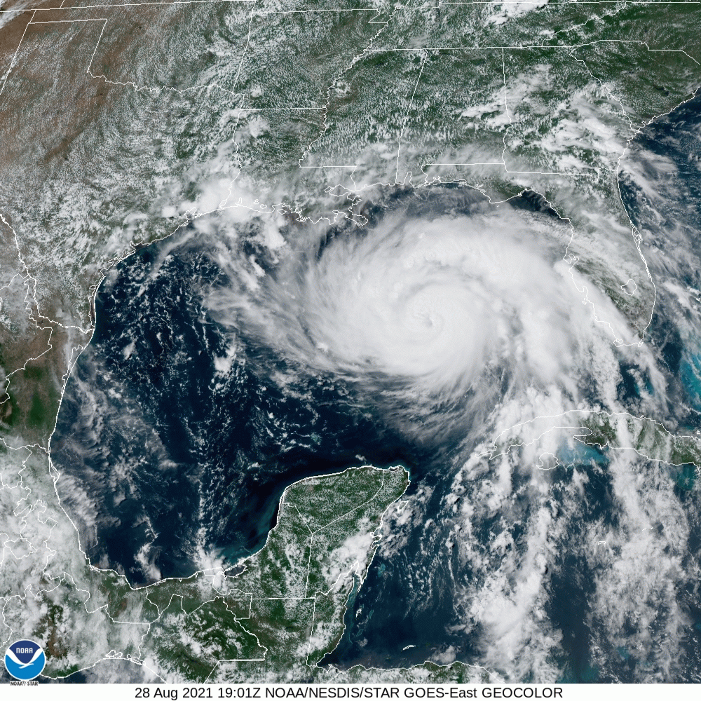
The National Weather Service has provided accurate and timely warnings for the people in the path of this storm who had pre-existing plans in place, but there are always people who didn’t.
A very dangerous storm!
/fl
Weather
Hurricane Ida
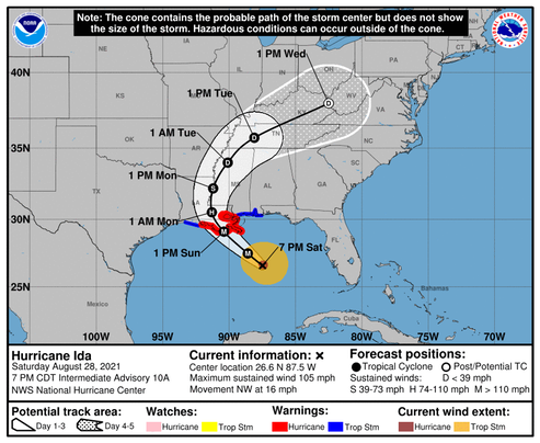
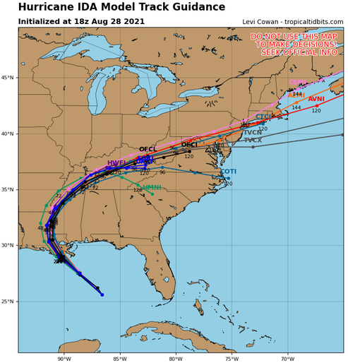
August 29th 2021 will mark the 16th anniversary of Hurricane Katrina in 2005; it looks like there is going to be an encore presentation! Hurricane Ida is ramping up just south of Cuba, and the forecast calls for a track that takes it near the track of Katrina.
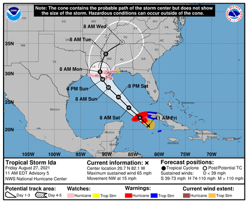
Ida is forecast to become a major hurricane, meaning it will have winds over 110 mph. The forecast indicates that Ida will make U.S. landfall near 91°W (vicinity of Houma, LA) with winds near 105 knots (121mph), gusting to 130 knots (150mph). If this forecast is correct, it will mean that New Orleans will again feel the effects of a major storm. Let’s hope and pray that they are better prepared than they were for Katrina.
Of course, these forecast’s are just that—an unknown prediction. For this storm, the daily forecast error has averaged between 150 and 175miles regarding the track, and near 15 knots in wind speed. Things can always change.
Watching.
/fl
Weather
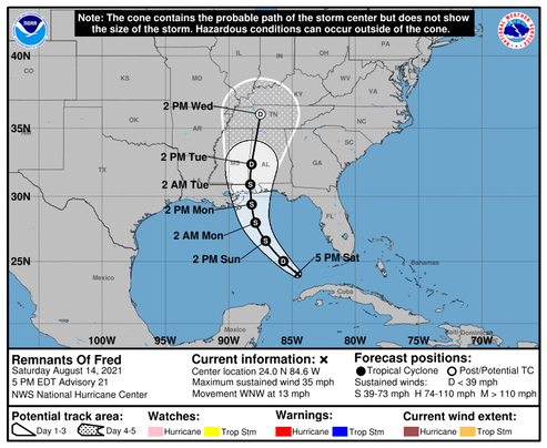
Update on Tropical Storm Fred
It looks like Fred has finally settled on Seaside [see update below], with the forecast wind speed of 50 knots, gusting to 60 knots at landfall today around 1400.
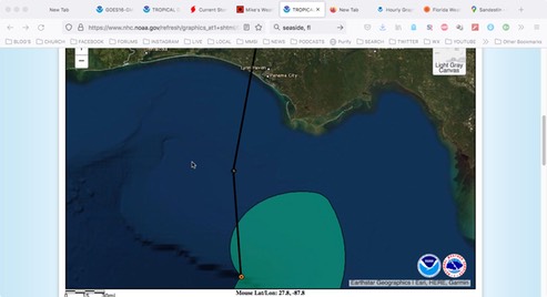
1000 Update: As an example of how difficult it is to predict these things, Fred has become a little better organized and altered course again to about 010°, which puts the forecast landfall in the vicinity of Panama City. It still appears that maximum windspeed will remain at or below 60 knots...
/fl
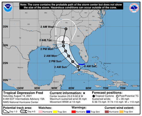
Weather
Update on Fred
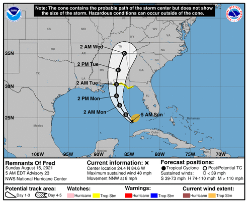
The latest forecast shows the storm’s predicted track moved east to the vicinity of Pensacola, and it could move even further east before coming ashore sometime early Tuesday morning. The intensity forecast still shows the storm's winds to be 45 knots with gusts to 55 knots at landfall.
UPDATE: The 1000CDT updated track forecast now shows the center of the storm coming ashore at 086.5’W which would put it in the Destin area. Fred is now expected to make landfall sometime Monday afternoon or evening. The intensity forecast for landfall remains steady at 45 knots with gusts to 50 knots.
Watching…
/fl
Weather
Update on Fred
Fred's forecast track keeps moving west... Track errors have averaged from 150NM to 175NM each day over the last two days. Intensity error has been steady at about 15 knots each day. It looks like the center of the storm will make landfall in Mississippi or Louisiana early Tuesday morning. So far, this is not a strong storm; hoping it stays that way…
/fl
Weather
Grace
Tropical storm Grace has formed in the Atlantic, and is following Fred.
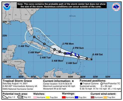
Tropical Storm Grace Discussion Number 5 NWS National Hurricane Center Miami FL AL072021 1100 AM AST Sat Aug 14 2021 Grace is sending mixed signals on its intensity this morning. The storm has been producing persistent convective bursting since overnight, which would suggest that some strengthening has occurred. The latest subjective data-T numbers are 2.5 (35 kt) from TAFB and SAB, while objective satellite estimates are higher, roughly between 45-50 kt. Then, an ASCAT pass from 1302 UTC showed winds between 35-40 kt. Given these data, the initial intensity is set at 40 kt. A NOAA Hurricane Hunter aircraft is scheduled to investigate Grace this afternoon to provide a better estimate of the storm's intensity. Grace is speeding along toward the west (280 degrees) at 19 kt. Mid-level ridging, entrenched over the western Atlantic, is expected to weaken slightly during the next couple of days. This evolution should cause Grace to slow down to 10-15 kt by Sunday night and Monday and take on a west-northwestward heading. That general trajectory should continue through the end of the forecast period. The track guidance is tightly clustered during the first 48-60 hours or so, showing Grace moving near or across the Leeward Islands, Puerto Rico, and the Dominican Republic. On days 3-5, there is a little more spread, with a few models keeping the system on a southern track across Cuba while others show tracks across the Bahamas. The NHC track forecast splits this difference and continues to show a track running between Cuba and the Bahamas, very close to the HCCA consensus solution. Deep-layer shear is forecast to be 10 kt or less for the next 36 hours or so while Grace is approaching the islands of the Greater Antilles. The thermodynamic environment also appears conducive for strengthening, but the system's continued fast motion is likely to be an inhibiting factor on the rate of intensification. The NHC intensity forecast remains on the conservative side, bringing Grace's intensity up to 50 kt by the time the storm reaches the Virgin Islands and Puerto Rico, but it should be noted that this forecast is on the lower side of the guidance. Only one model, the HWRF, brings Grace to hurricane strength, but it does this by having the storm move farther north and avoid land interaction altogether. The intensity forecast is highly uncertain on days 3-5 since it depends on exactly how much Grace moves over the Greater Antilles, and there is some model signal that increasing northeasterly upper-level winds over the Bahamas and Florida could become a negative factor.
We’ll see where this one is headed...
/fl
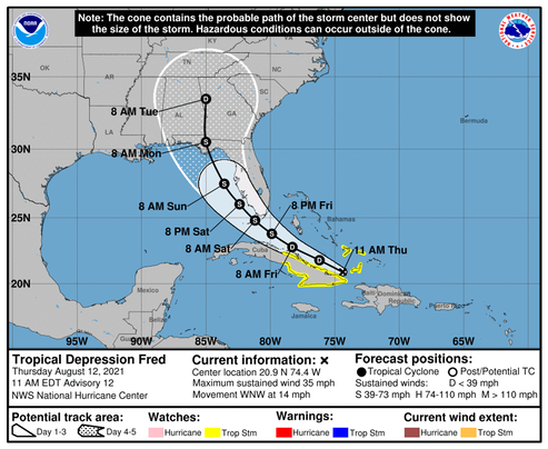
Weather
Fred Update
significant intensification seems unlikely as southerly shear is anticipated to increase before the system reaches the Gulf coast on Monday.—NHC
As expected, the forecast path of Fred has moved to the west. The intensity forecast has remained the same: around 50 knots at landfall.
Watching…
/fl
Weather
Fred
As expected, the forecast landfall of this storm has moved west into the area of the central panhandle, however the wind strength at landfall remains around 50 knots. There is still quite a bit of uncertainty due to the movement of upper-air current. More will be known as the storm moves into the gulf of mexico.
Watching...
/fl
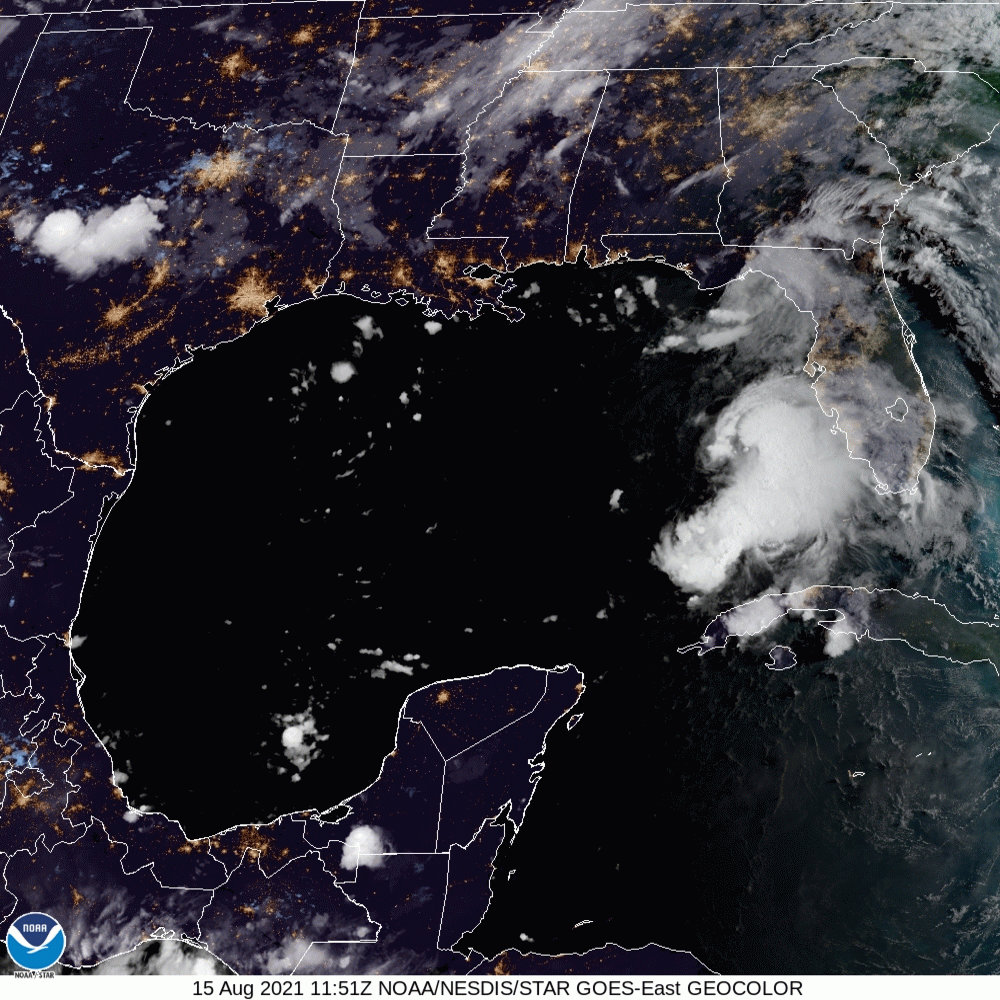
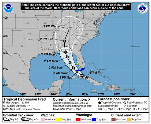
Weather
Fred
Tropical Depression Fred is forecast to become a Tropical Storm with wind speeds of 50 knots or less. The NHC forecast track has the storm making landfall in the vicinity of Cape San Blas, but there is still some potential for ‘wobble’ in the proposed track. In addition to that uncertainty, the intensity of these things is still an inexact science, so the entire Emerald Coast is keeping an eye on this one.
Watching…
/fl
Weather
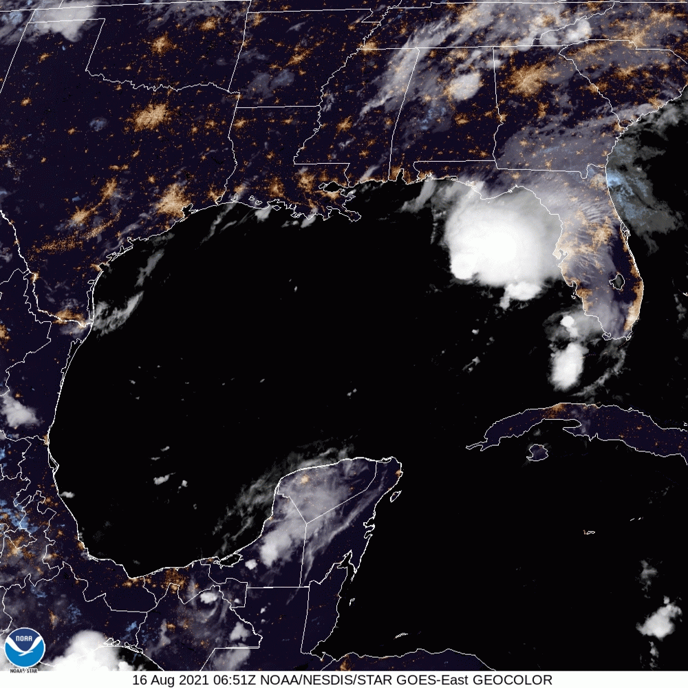
Potential Tropical Cyclone Six
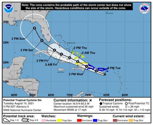
It’s still a little early to tell, but this one appears to be headed for the Big Bend area of the Gulf of Mexico. Right now, the forecast wind is below hurricane strength, but it still has a ways to go and a lot can change.
Watching...
/fl