
Blog
Weather
Hurricane Zeta
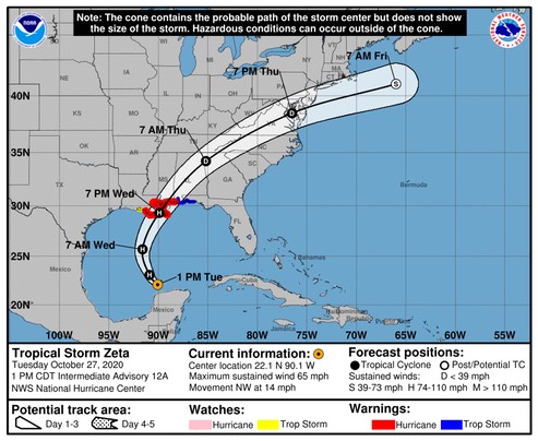
Aside from some speed differences, the track models are in good agreement and have shown good run-to-run consistency. The official track forecast is about the same as the previous one and close to the model consensus. Given Zeta's acceleration near landfall, strong winds are likely to spread well inland along the northern Gulf coast Wednesday night.
/NOAA
Windspeed forecast for Pensacola:
/fl
Weather
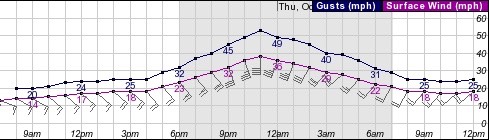
TD-28; “Zeta"
The center is difficult to locate at this time, and the best estimate for motion is quasi-stationary. A high pressure area developing near Florida should induce a general northwestward motion over the next couple of days. Later, a shortwave trough approaching from the west is likely to cause Zeta to turn northward and north-northeastward while it nears the northern Gulf Coast in 72-84 hours. The official track forecast lies between the GFS solution which is farther east and the ECMWF prediction which lies farther south and west. Given the favorable upper-level outflow pattern and very high oceanic heat content over the northwestern Caribbean, strengthening is likely until the center moves near or over the Yucatan Peninsula late tomorrow. Zeta should be near or at hurricane strength when it approaches the Yucatan. The official intensity forecast for the next 36 hours is close to the model consensus. After Zeta moves into the central Gulf of Mexico, increasing southwesterly shear and diminishing oceanic heat content are expected to prevent strengthening. The NHC intensity forecast over the Gulf is above the latest model consensus. Although not explicitly shown in the official forecast, the unfavorable atmospheric and oceanic conditions over the northern Gulf of Mexico could cause Zeta to weaken by the time the center nears the northern Gulf coast. However, users are reminded that these intensity forecasts are subject to uncertainty.
/NOAA
Another reminder that tropical storm season 2020 is not over yet!
/fl
Weather
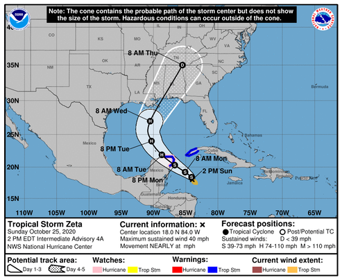
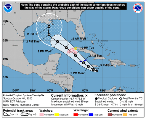
Tropical Depression #28
The system is forecast to approach the northern Gulf Coast as a tropical storm on Wednesday, and could bring storm surge, rainfall, and wind impacts to areas from Louisiana to the Florida Panhandle. Residents in these areas should monitor the progress of the depression and updates to the forecast.
FORECAST POSITIONS AND MAX WINDS
INIT 24/2100Z 18.7N 83.0W 25 KT 30 MPH
12H 25/0600Z 19.0N 83.2W 30 KT 35 MPH
24H 25/1800Z 19.5N 83.5W 35 KT 40 MPH
36H 26/0600Z 20.1N 84.2W 40 KT 45 MPH
48H 26/1800Z 20.9N 85.6W 45 KT 50 MPH
60H 27/0600Z 22.0N 87.5W 55 KT 65 MPH
72H 27/1800Z 23.4N 89.4W 65 KT 75 MPH
96H 28/1800Z 27.5N 91.0W 55 KT 65 MPH
120H 29/1800Z 35.5N 84.5W 25 KT 30 MPH...POST-TROP/EXTRATROP
It looks like this system might not drop below 1000mb. We’ll see.
Watching...
/fl
Culture
And The Beat Goes On...
Miami road to be named after Trayvon Martin
A Florida road will be named after a Black teenager whose death by a neighborhood watch volunteer in 2012 catalyzed a movement for racial justice.
The Miami Herald reports Trayvon Martin's name will be added to a section of an avenue that leads to a high school he attended in Miami-Dade County.
Martin was shot dead in Sanford, Florida, at 17 while on a visit with his father.
The teen was unarmed and walking back from a convenience store with candy when he was shot by George Zimmerman.
… I know what you’re thinking: Is it intellectual dishonesty—or is it intellectual deficiency? To tell you the truth, the symbiosis between those two conditions makes it difficult for me to distinguish any difference…
If the myth of innocence of Trayvon Martin is allowed to stand this close in time to a comprehensive accounting of the true “sworn” facts, it will probably stand forever.
Theologians refer to this sort of thing as “the noetic effect of the fall.”
-fl
Weather
Hurricane Delta Wind Field
It looks like Pensacola will be outside the feeder-bands that cause so much uncertainty during these events. Here is the wind forecast data for Friday; southeasterly winds in the high teen’s, gusting to around 30mph.
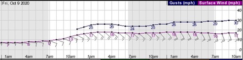
-NOAA
/fl
Firearms
"Long Live the Lever Gun”
Thursday, October 1, 2020
Sturm, Ruger & Company, Inc. to Acquire Marlin Firearms AssetsSturm, Ruger & Company, Inc. (NYSE: RGR) announced today that its offer to purchase substantially all of the Marlin Firearms assets was accepted by Remington Outdoor Company, Inc. and approved by the United States Bankruptcy Court for the Northern District of Alabama. The Company will pay the $30 million purchase price from cash on hand at the time of closing, which is expected to occur in October.
"The value of Marlin and its 150-year legacy was too great of an opportunity for us to pass up," said Ruger President and CEO Chris Killoy. "The brand aligns perfectly with ours and the Marlin product portfolio will help us widen our already diverse product offerings."
The transaction is exclusively for the Marlin Firearms assets. Remington firearms, ammunition, other Remington Outdoor brands, and all facilities and real estate are excluded from the Ruger purchase. Once the purchase is completed, the Company will begin the process of relocating the Marlin Firearms assets to existing Ruger manufacturing facilities.
"The important thing for consumers, retailers and distributors to know at this point in time," continued Killoy, "is that the Marlin brand and its great products will live on. Long Live the Lever Gun.”
-www.theoutdoorwire.com
Being of the old 'one target-one shot’ school, I personally prefer lever-action over a semi-automatic, so this announcement came as good news. Ruger builds good quality firearms, and I’m confident that they will extend that quality control to their prospective line of “Ruger-Marlin” lever-action rifles.
Incidentally, Federal has a new line of bonded ammunition, offered in a variety of calibers, that is specifically designed for lever-action rifles; though at the moment, it’s hard to find.
/fl
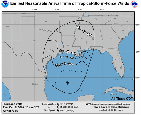
Weather
Hurricane Delta
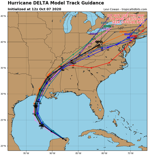
Once Delta moves over the southern Gulf of Mexico, warm waters and expected low vertical wind shear conditions are expected to allow for re-strengthening during the next 24 to 36 hours. After 48 hours, increasing southwesterly shear and cooler waters over the northern Gulf are likely to induce some weakening. The intensity guidance has trended downward this cycle, and the NHC forecast has been adjusted accordingly. Delta, however is still expected to regain major hurricane status and the wind field is likely to grow in size during its approach to the northern Gulf coast, which will increase the storm surge and wind threats. Regardless of Delta's landfall intensity, life-threatening storm surge and strong winds are likely over a large portion of the northwestern and northern Gulf coast, which has necessitated the issuance of Storm Surge, Hurricane, and Tropical Storm watches for portions of that area. Delta is moving northwestward or 305/15 kt. The hurricane should continue moving northwestward around the southwestern portion of a subtropical ridge that extends over Florida and the northeastern Gulf of Mexico through early Thursday. After that time, a developing mid-level trough over the south-central United States should cause Delta to slow down and turn north-northwestward on Thursday. Delta is forecast to begin accelerating northward or north-northeastward toward the northern Gulf coast ahead of the trough Thursday night and Friday. There has been little change to the early portion of the track forecast, but there has been a little westward shift in the guidance envelope after 24 hours, and the NHC forecast has been moved in that direction. The new forecast track lies near or just left of the TVCA multi-model consensus and a little right of the HFIP corrected consensus aid, again close to the GFS, GFS ensemble mean, and UKMet models.
/NOAA
A definite consensus of the model’s on this one, but still watching.
/fl
Weather
Tropical Cyclone Number 26 - “Delta"
We’re warily watching this system. Not much has changed over the last 24-hours regarding the forecast track or intensity.
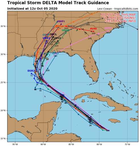
thanks to tropicaltidbits.com
/fl
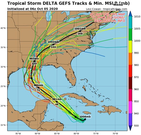
Weather
Tropical Cyclone Number 26 - “Delta"
Here we go again…. A lively year indeed!
The system is forecast to approach the northern Gulf Coast late this week as a hurricane. While there is large uncertainty in the track and intensity forecasts at these time ranges, there is a risk of dangerous storm surge, wind, and rainfall hazards along the coast from Louisiana to the western Florida Panhandle
NOAA
Watching closely...
/fl