
Tropical Depression #28
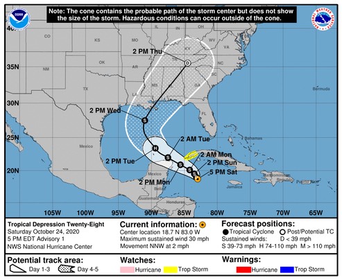
The system is forecast to approach the northern Gulf Coast as a tropical storm on Wednesday, and could bring storm surge, rainfall, and wind impacts to areas from Louisiana to the Florida Panhandle. Residents in these areas should monitor the progress of the depression and updates to the forecast.
FORECAST POSITIONS AND MAX WINDS
INIT 24/2100Z 18.7N 83.0W 25 KT 30 MPH
12H 25/0600Z 19.0N 83.2W 30 KT 35 MPH
24H 25/1800Z 19.5N 83.5W 35 KT 40 MPH
36H 26/0600Z 20.1N 84.2W 40 KT 45 MPH
48H 26/1800Z 20.9N 85.6W 45 KT 50 MPH
60H 27/0600Z 22.0N 87.5W 55 KT 65 MPH
72H 27/1800Z 23.4N 89.4W 65 KT 75 MPH
96H 28/1800Z 27.5N 91.0W 55 KT 65 MPH
120H 29/1800Z 35.5N 84.5W 25 KT 30 MPH...POST-TROP/EXTRATROP
It looks like this system might not drop below 1000mb. We’ll see.
Watching...
/fl