
TD-28; “Zeta"
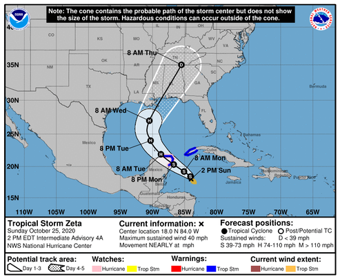
The center is difficult to locate at this time, and the best estimate for motion is quasi-stationary. A high pressure area developing near Florida should induce a general northwestward motion over the next couple of days. Later, a shortwave trough approaching from the west is likely to cause Zeta to turn northward and north-northeastward while it nears the northern Gulf Coast in 72-84 hours. The official track forecast lies between the GFS solution which is farther east and the ECMWF prediction which lies farther south and west. Given the favorable upper-level outflow pattern and very high oceanic heat content over the northwestern Caribbean, strengthening is likely until the center moves near or over the Yucatan Peninsula late tomorrow. Zeta should be near or at hurricane strength when it approaches the Yucatan. The official intensity forecast for the next 36 hours is close to the model consensus. After Zeta moves into the central Gulf of Mexico, increasing southwesterly shear and diminishing oceanic heat content are expected to prevent strengthening. The NHC intensity forecast over the Gulf is above the latest model consensus. Although not explicitly shown in the official forecast, the unfavorable atmospheric and oceanic conditions over the northern Gulf of Mexico could cause Zeta to weaken by the time the center nears the northern Gulf coast. However, users are reminded that these intensity forecasts are subject to uncertainty.
/NOAA
Another reminder that tropical storm season 2020 is not over yet!
/fl