
Blog
Weather
Laura (Update)
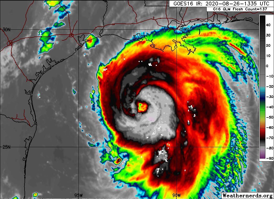
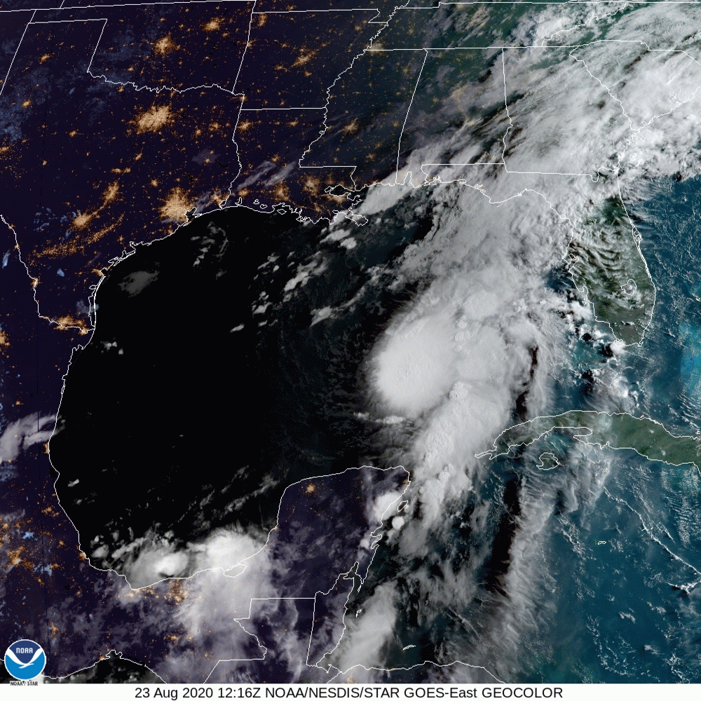
Laura has become a very powerful hurricane this morning. The satellite presentation has continued to improve with the eye becoming better defined, and cloud tops colder than -70C in the surrounding ring of deep convection. Both NOAA and Air Force hurricane hunter aircraft have provided valuable data this morning. The NOAA P-3 aircraft reported a peak flight-level wind of 125 kt at 8000 ft, and a peak SFMR wind of 104 kt, while the Air Force crew has observed peak 700-mb flight-level winds of 121 kt and peak SFMR winds of 104 kt. The lastest minimum pressure estimated from aircraft data is 956 mb, indicating a pressure drop of 27 mb over the past 12 hours. Based on the aircraft data, the initial wind speed was increased to 100 kt on the 1200 UTC intermediate advisory, and is now set at 110 kt based on the latest flight-level and SFMR winds. Laura is likely to continue strengthening today while it moves over warm waters of the northwestern Gulf of Mexico and the vertical wind shear remains low. Laura's intensity could level-off by this evening due to the possibility of an eyewall replacement cycle and the expected increase in shear around the time of landfall. Even if the rate of strengthening eases, Laura is expected to be an extremely powerful category 4 hurricane when it reaches the northwestern Gulf coast. After landfall, rapid weakening will occur, but Laura will bring a swath of damaging winds well inland over western Louisiana and eastern Texas.
/NOAA
Weather
Laura (Update)
Laura crosses the Western end of Cuba, and gains strength as it heads for the U.S. Gulf Coast.
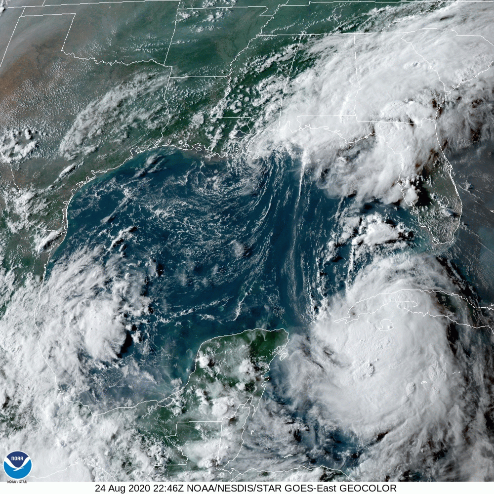
The storm is starting to pull away from the western portion of Cuba, and it should be over the warm Gulf of Mexico waters for about 2 days. Since Laura will have a notable amount of time over waters with high oceanic heat while moving through a low wind shear and high moisture air mass, significant strengthening seems quite likely until the storm makes landfall. The intensity models all show Laura making landfall as a hurricane, but there are differences on exactly how strong it will be. The NHC intensity forecast continues to stay near the consensus aids, which usually perform best, and Laura could be near major hurricane strengthen when it reaches the coast.
This does not look good!
/fl
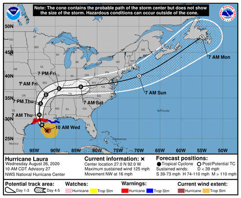
Weather
Laura (Update)
This is interesting. Hurricane Marco is already in the Gulf of Mexico, running ahead of Laura, but has not developed an eye—yet.
Bringing up the rear, Laura is now forecast to make landfall near the TX/LA border.
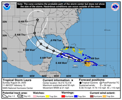
Although the center of Laura was been difficult to track while it passed over Hispaniola, the estimated motion is west-northwestward at about 18 kt. A strong deep-layer ridge over the western Atlantic should continue to steer Laura west-northwestward for the next couple of days. The track guidance has continued to nudge southward during the first 36 hours and the official forecast has been adjusted accordingly, taking the storm closer to the southern coast of Cuba. After that time, the ridge is forecast to build westward over the eastern Gulf of Mexico. This pattern should allow Laura to maintain a west-northwestward motion until it approaches the central Gulf, where a northwestward motion is expected to begin as the storm nears the western periphery of the ridge. The dynamical models have trended toward stronger ridging over the eastern Gulf, resulting in a westward shift in the guidance. The NHC track forecast has been moved westward at 72-96 hours, and lies between the GFS and ECMWF solutions. Users are reminded to not to focus on the exact details of the track forecast at the longer range as future adjustments will likely be required, and storm hazards will extend far from the center.
NOAA-NHC
Weather
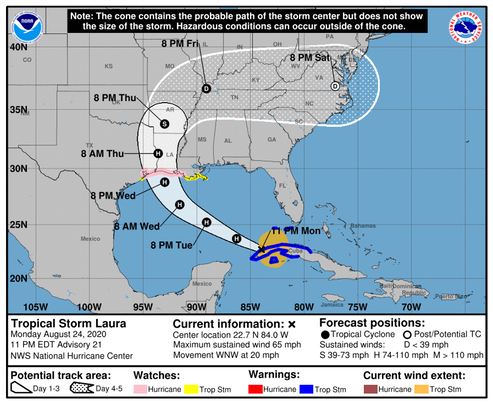
Laura
From NOAA-NHC
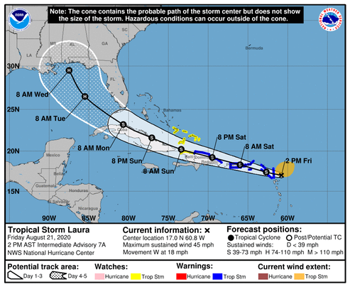
The details of the long-range track and intensity forecasts remain more uncertain than usual since Laura is forecast to move near or over portions of the Greater Antilles through Monday. However, Laura could bring storm surge, rainfall, and wind impacts to portions of Cuba, the Bahamas, and Florida early next week and the northeast U.S. Gulf Coast by the middle of next week. Interests there should monitor the progress of Laura and updates to the forecast over the next few days.
We’ll be watching this one closely!
/fl
History
Reminiscing Ocean Station duty—and why we were there.
The following series of recently produced video’s re-creates the not-too-distant era of commercial aviation when trans continental air travel was a true adventure.
My duty in the United States Coast Guard included crewing aboard a USCG Cutter serving as an Ocean Station Vessel in the North Atlantic ocean. During the time that I was aboard, we manned Ocean Station’s “Bravo” and “Charlie.” The duty involved being “on station” (as close to the center of a 210 mile square that weather would allow) for a period of 21 days at a time, plus travel time to and from our home port of Norfolk, VA, followed by “shore time” which included repair and replenishment. Winter in the North Atlantic can be pretty demanding on equipment, so we usually had plenty of repair work to do in port.
Take a brief journey back in time...
The following photo of the U.S. Coast Guard Cutter Chincoteague (W-375) was taken in 1964 while I was aboard. The tripod mast nearest the stern supported our air-search radar antenna. The radar screens, VHF/UHF radio phones, plotting displays, and most of the equipment used for providing “flight services” to the airlines and commercial aviation were located in the Combat Information Center (CIC) which was located between the forward mast (the one with the flags), and the Bridge (located behind the row of round portholes.) A lively place in rough weather; this was before the days of automatic electronic displays; we calculated all speeds with a circular slide-rule, and plotted distances and positions with a grease pencil; there were days when we worked the aircraft with one hand while holding on with the other!
A brief ship’s history can be found here.
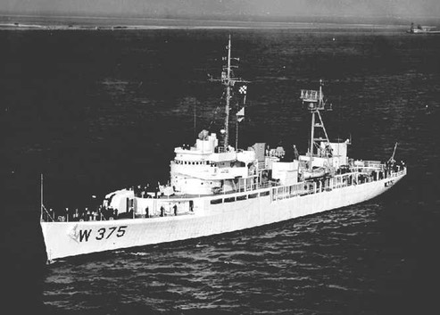
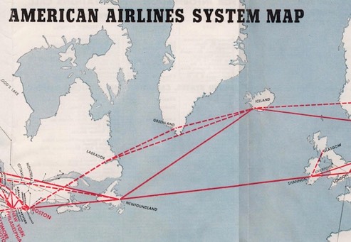
Chart showing then-existent North Atlantic Ocean Station Location’s:
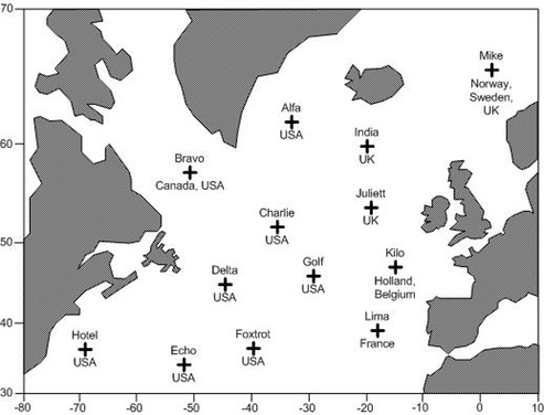
Back in the 1960’s, Ocean Station “Bravo”, located at 56.5°N-51.0°W, was roughly the “point of no return” for aircraft traveling between Newfoundland and Greenland. We were there to assist anyone who might be having trouble, be it in the air or on the water. In addition to reporting and tracking icebergs for the safety of surface ships, we served as a floating flight-service station for trans Atlantic aircraft carrying passengers, cargo, and airmail.
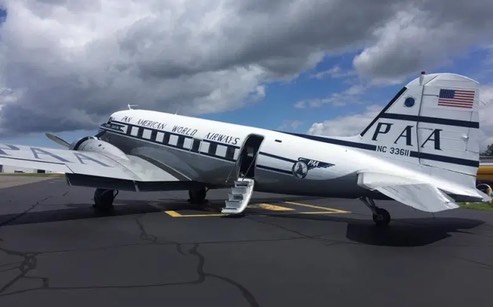
Piston engined, non-pressurized, aircraft, such as the DC-3 (shown in Pan American World Airways “Clipper” colors) in this series of video’s are limited in their maximum altitude, in order for the engines to function (breathe) properly, and for the people on-board to be able to breathe without oxygen masks. This means that those types of aircraft cannot fly high enough to get over the weather, and must fly around any storms that they encounter in their path. That was one of our jobs; helping them avoid adverse wind and weather conditions. The air space over the North Atlantic ocean between Newfoundland and Greenland is controlled by Gander Oceanic Air Control (OAC) at Gander, Newfoundland, and all trans-oceanic flights were required to carry a High Frequency (HF) radio, in addition to the VHF radio that they use to communicate with airport towers. Even then, “radio relay” was common between aircraft—as seen demonstrated in the video.
With the exception of emergency rescue operations, our primary routine on Ocean Station was to track all aircraft that appeared on our radar, contact each flight, copy their flight data (critical progress) information, and provide course and speed information to the flight crew—along with the latest North Atlantic weather; in addition we could relay radio traffic between Gander OAC and any aircraft flying over our Ocean Station. It was common for us to get flight-level change requests due to unfavorable winds at various altitudes; these requests were received from the flight crews and relayed to Gander OAC via HF—upon approval by Gander, the clearance was relayed to the requesting flight by VHF. The process sounds unwieldy and cumbersome by todays standards, but it was state-of-the-art in the early 1960’s. Since the DC-3 aircraft used in this video has been retrofitted with more modern communications gear, they were able to get an “HF waiver” for their 1,000 mile over-water leg to Narsarssuak, Greenland and beyond to Prestwick, Scotland.
I worked four-hour watches in the Combat Information Center (CIC) tracking aircraft and copying flight data. The traffic was light by today’s standards, but hardly any 4-hour watch went by that I didn’t talk to one or more “Clipper” crews amongst the variety of other airlines. At the time, most of the airline aircraft were pressurized, with either supercharged radial or jet engines, and had more altitude options than the old DC-3 in these video’s—but there were a few just like this one.
The year 1977 saw the last of the U.S. Coast Guard Ocean Station Vessel’s, but these video’s provide a taste of the old days—what it was like for early to mid-twentieth century flight crews flying the old Ocean Station routes across the Atlantic, and why we sat out there helping them.
Semper Paratus!
/fl
UPDATE 02-25-2021: This has nothing to do with the subject matter of the above story, but it turns out that one of the “pilots” in this story received his DC-3 type rating from Dan Gryder, and the subject in question was later involved in some questionable activity; you can see more details regarding that at https://www.youtube.com/watch?v=4J10p7yzvEw.
/fl
Navigation
Skinny Water
One of the ground rules (pun intended) of sailing is: ‘Don’t try to go where the birds are walking.' That rule applies to jet skis also.
Surface wetness and water depth are two entirely different things!
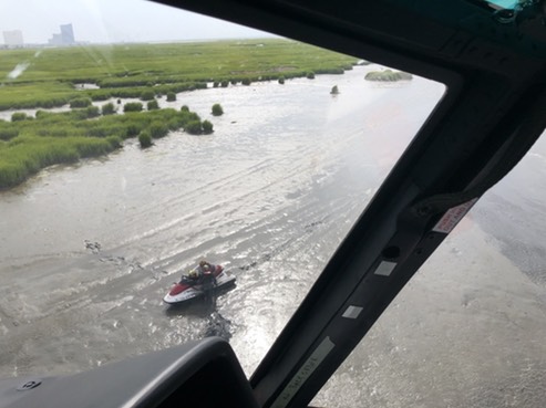
Coast Guard rescues 2 from stranded jet ski
BRIGANTINE, N.J. — The Coast Guard rescued two people who were stranded on a jet ski that ran aground in near Brigantine, New Jersey, Monday evening.
Watchstanders at the Coast Guard Sector Delaware Bay command center were notified at approximately 4 p.m., from the mother one of the passengers regarding two people in need of assistance after running their jet ski aground in the marsh.
A MH-65 Dolphin helicopter aircrew from Coast Guard Air Station Atlantic City was launched to the scene to recover the two people.
Once on scene, the aircrew safely hoisted the two people aboard the helicopter and transported them back to Coast Guard Station Atlantic City.
/uscg
Semper Paratus, and Happy Birthday to all Coasties, past and present!
/fl