
Blog
Marine Safety
Truth Aquatics: The Conception Fire Investigation
The National Transportation Safety Board Docket is available online, and the full report of the investigation of this incident can be read at the NTSB website.
/fl
Weather
Hurricane Sally Cleanup
Sally made a mess, but with the help of good neighbors and several hundred visiting line crews, we are able to resume a fairly normal life here in Pensacola. There are tons of debris yet to be removed, but that will get done in orderly fashion.
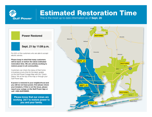
Sally hit on the 16th anniversary of hurricane Ivan, in almost the exact same spot. Rest assured that September the 16th will be a date to be remembered for residents of Pensacola and surrounding area.
/fl
Weather
Sally
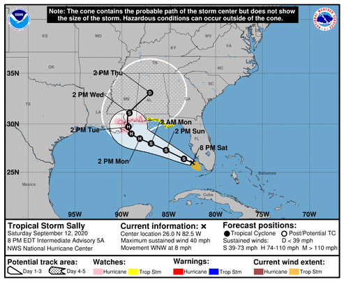
The forecast track of Tropical Storm Sally has been moved slightly west. The storm is forecast to intensify to a category 1 hurricane before making landfall in Mississippi. There is still a tropical storm watch issued for Pensacola, but winds are forecast to be below 20 mph, with gusts to around 22-25. We’ll see...
/fl
Weather
Tropical Depression Nineteen Sally
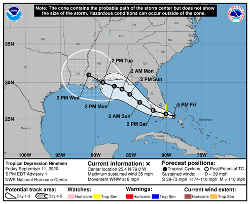
[A]fter the system reaches the eastern Gulf of Mexico, steady intensification is expected through the weekend due to expected light wind shear and very warm water. Some increase in shear could occur over the northern Gulf of Mexico but that is uncertain at this time….. Strong ridging over the southeastern United States is expected to steer the cyclone to the west-northwest then northwest as a mid-latitude trough erodes the western side of the ridge over the weekend. The forecast gets tricky after that… The uncertainty in the track forecast is much larger than normal after 48 hours, as small changes in the forecast steering flow could result in this system moving over the northern Gulf Coast faster and to the northeast of what is shown here. As a result, the risk of seeing direct impacts from this system extends well outside the cone of uncertainty, even more so than usual in this case.
/NOAA
At this time, the maximum intensity forecast calls for “Storm” winds at or below 60 knots, but due to the fact that the track of this storm is uncertain, we should assume the intensity could change; we’ll know more when the system crosses the peninsula and enters the Gulf of Mexico.
Watching
/fl
Baseball
3-2-8 Double Play!
ST. LOUIS -- It’s not every day you see a catcher running down a baserunner in between second and third base, and a center fielder applying the tag at second base.
That’s the wacky double play the Cardinals turned in the second inning of Friday’s 14-2 loss in the series opener against the Indians at Busch Stadium. On Francisco Lindor’s grounder with no outs and runners on first and third base, Cards first baseman Paul Goldschmidt threw home to catcher Yadier Molina, who then tagged out Cesar Hernandez in a rundown on the third-base line.
Then, Molina chased José Ramírez and Lindor back to second and first base, respectively. About halfway between second and third base, Molina looked like he might throw to first base to get Lindor. But he turned and threw to center fielder Dylan Carlson covering second base to tag Ramírez out.
It went down in the scorebook as a 3-2-8 double play -- which has not happened in the expansion era (since 1961), according to the Elias Sports Bureau.
….. but, back in 1961, there was actually a live crowd present to watch the drama!
Nice play!
/fl