
Tropical Depression Nineteen Sally
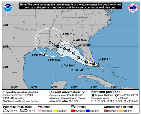
[A]fter the system reaches the eastern Gulf of Mexico, steady intensification is expected through the weekend due to expected light wind shear and very warm water. Some increase in shear could occur over the northern Gulf of Mexico but that is uncertain at this time….. Strong ridging over the southeastern United States is expected to steer the cyclone to the west-northwest then northwest as a mid-latitude trough erodes the western side of the ridge over the weekend. The forecast gets tricky after that… The uncertainty in the track forecast is much larger than normal after 48 hours, as small changes in the forecast steering flow could result in this system moving over the northern Gulf Coast faster and to the northeast of what is shown here. As a result, the risk of seeing direct impacts from this system extends well outside the cone of uncertainty, even more so than usual in this case.
/NOAA
At this time, the maximum intensity forecast calls for “Storm” winds at or below 60 knots, but due to the fact that the track of this storm is uncertain, we should assume the intensity could change; we’ll know more when the system crosses the peninsula and enters the Gulf of Mexico.
Watching
/fl