
Hurricane Delta
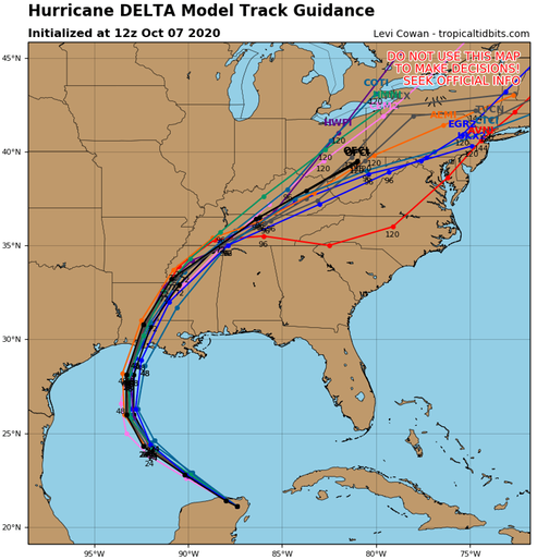
Once Delta moves over the southern Gulf of Mexico, warm waters and expected low vertical wind shear conditions are expected to allow for re-strengthening during the next 24 to 36 hours. After 48 hours, increasing southwesterly shear and cooler waters over the northern Gulf are likely to induce some weakening. The intensity guidance has trended downward this cycle, and the NHC forecast has been adjusted accordingly. Delta, however is still expected to regain major hurricane status and the wind field is likely to grow in size during its approach to the northern Gulf coast, which will increase the storm surge and wind threats. Regardless of Delta's landfall intensity, life-threatening storm surge and strong winds are likely over a large portion of the northwestern and northern Gulf coast, which has necessitated the issuance of Storm Surge, Hurricane, and Tropical Storm watches for portions of that area. Delta is moving northwestward or 305/15 kt. The hurricane should continue moving northwestward around the southwestern portion of a subtropical ridge that extends over Florida and the northeastern Gulf of Mexico through early Thursday. After that time, a developing mid-level trough over the south-central United States should cause Delta to slow down and turn north-northwestward on Thursday. Delta is forecast to begin accelerating northward or north-northeastward toward the northern Gulf coast ahead of the trough Thursday night and Friday. There has been little change to the early portion of the track forecast, but there has been a little westward shift in the guidance envelope after 24 hours, and the NHC forecast has been moved in that direction. The new forecast track lies near or just left of the TVCA multi-model consensus and a little right of the HFIP corrected consensus aid, again close to the GFS, GFS ensemble mean, and UKMet models.
/NOAA
A definite consensus of the model’s on this one, but still watching.
/fl