
Grace
Tropical storm Grace has formed in the Atlantic, and is following Fred.
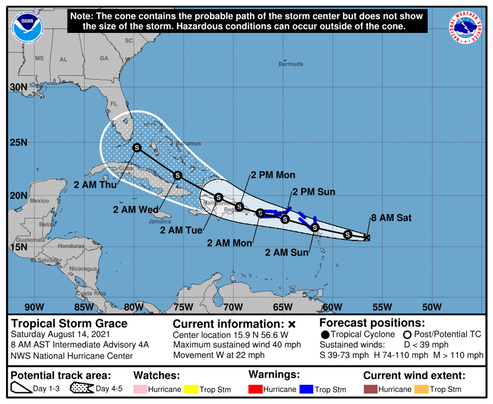
Tropical Storm Grace Discussion Number 5 NWS National Hurricane Center Miami FL AL072021 1100 AM AST Sat Aug 14 2021 Grace is sending mixed signals on its intensity this morning. The storm has been producing persistent convective bursting since overnight, which would suggest that some strengthening has occurred. The latest subjective data-T numbers are 2.5 (35 kt) from TAFB and SAB, while objective satellite estimates are higher, roughly between 45-50 kt. Then, an ASCAT pass from 1302 UTC showed winds between 35-40 kt. Given these data, the initial intensity is set at 40 kt. A NOAA Hurricane Hunter aircraft is scheduled to investigate Grace this afternoon to provide a better estimate of the storm's intensity. Grace is speeding along toward the west (280 degrees) at 19 kt. Mid-level ridging, entrenched over the western Atlantic, is expected to weaken slightly during the next couple of days. This evolution should cause Grace to slow down to 10-15 kt by Sunday night and Monday and take on a west-northwestward heading. That general trajectory should continue through the end of the forecast period. The track guidance is tightly clustered during the first 48-60 hours or so, showing Grace moving near or across the Leeward Islands, Puerto Rico, and the Dominican Republic. On days 3-5, there is a little more spread, with a few models keeping the system on a southern track across Cuba while others show tracks across the Bahamas. The NHC track forecast splits this difference and continues to show a track running between Cuba and the Bahamas, very close to the HCCA consensus solution. Deep-layer shear is forecast to be 10 kt or less for the next 36 hours or so while Grace is approaching the islands of the Greater Antilles. The thermodynamic environment also appears conducive for strengthening, but the system's continued fast motion is likely to be an inhibiting factor on the rate of intensification. The NHC intensity forecast remains on the conservative side, bringing Grace's intensity up to 50 kt by the time the storm reaches the Virgin Islands and Puerto Rico, but it should be noted that this forecast is on the lower side of the guidance. Only one model, the HWRF, brings Grace to hurricane strength, but it does this by having the storm move farther north and avoid land interaction altogether. The intensity forecast is highly uncertain on days 3-5 since it depends on exactly how much Grace moves over the Greater Antilles, and there is some model signal that increasing northeasterly upper-level winds over the Bahamas and Florida could become a negative factor.
We’ll see where this one is headed...
/fl