
Dorian
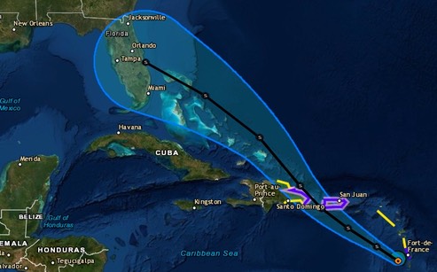
At this writing, Dorian is forecast to come ashore as a tropical storm (39-73 mph winds) along the East coast of the Florida peninsula sometime around 0800 Sunday. But, just how accurate is that forecast?
Users are reminded not to focus on the details of the extended track forecast as the average 5-day track error is around 200 miles.
Dry air continues to plague Dorian, and interaction with the mountainous terrain of St. Lucia will likely hinder significant development in the short term. However, the models continue to indicate that the upper-level flow pattern and shear conditions are expected to remain favorable for strengthening throughout the forecast period, so it is uncertain why the dynamical models are not showing more development and strengthening when compared to the more robust statistical SHIPS intensity models, especially at days 4 and 5 when Dorian will be moving over SSTs greater than 29 deg C and into a fairly moist environment. For now, the official intensity forecast remains basically midway between the stronger SHIPS model and the much weaker global and regional models. Given the large spread in the guidance, there is lower than normal confidence in the intensity forecast, especially on days 4 an 5.
Just what will happen when Dorian gets over the Gulf Stream? This is a tricky one!
/fl