
Tropical Storm (soon to become Hurricane) Michael
In keeping with past cases, the forecast storm track has remained fairly steady, but the intensity potential is still in doubt.
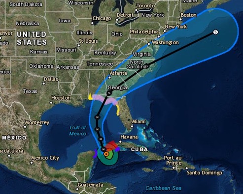
NWS National Hurricane Center Miami FL AL142018 400 AM CDT Mon Oct 08 2018
Michael has become better organized this morning, with the deep convection migrating westward on top of the low-level center and upper-level outflow beginning to increase within the western semicircle. An Air Force Reserve Hurricane Hunter aircraft made several passes through the system during the past few hours, and somewhat surprisingly, found that the central pressure has fallen to about 983 mb and maximum winds have increased to near 60 kt. This increase in intensity indicates that despite the shear which has been affecting Michael, the system has, by definition, rapidly intensified during the past 24 hours. With the increase in the initial wind speeds, the official intensity forecast is higher than in the previous forecast. Decreasing vertical shear and very warm sea surface temperatures are expected to support continued strengthening, and due to the favorable conditions, the NHC intensity forecast follows a blend of the IVCN consensus and the HCCA model. This new official forecast brings the intensity to just below major hurricane strength in 48 hours, and since the storm will still be over water for a time between 48 and 72 hours, there is a real possibility that Michael will strengthen to a major hurricane before landfall...
The current forecast for Pensacola shows storm force winds probably arriving Wednesday morning, with surface wind building to around 25 mph, with 37 mph gusts, by 0700 Wednesday. That could change though.
/fl