
Grounding on Long Island Sound
Here is yet another case regarding why I claim that 'navigation waste is hazardous waste’; In this case a new $300,000 motor boat being delivered from Stewart, Florida to Portsmouth, New Hampshire winds up on a well-marked, well-charted shoal.
Anyone who has been sailing (or motoring) long enough has no doubt experienced at least one time when they felt overwhelmed with unforeseen conditions, be it weather conditions or mechanical failure. But, here we have a case where a boat runs over a marked obstruction in broad daylight. What happened?
The story, as it appeared in the Stamford Advocate:
STAMFORD — A New Hampshire man and his delivery captain are safe following a harrowing rescue off Sheffield Island Wednesday morning in a newly purchased powerboat he was motoring from Stuart, Florida home to Portsmouth.
Sgt. Peter Lapak, head of the Norwalk Police Department’s Marine Division, said it was a particularly difficult rescue. As the tide came up the 39-foot boat, valued at $300,000, sank, right after the rescue was made, Lapak said.
“In my whole career this was one of the worst ones, one of the most dangerous ones because of where we had to go, on top of the reef, and the sea conditions — the water was really cold,” said Lapak, a 26-year veteran of the Marine Division, about an hour after returning to shore from the rescue. “I’m really glad the guys were OK. They can get another boat.”
Norwalk Police Lt. Jared Zwickler said the marine unit responded to the call of a boat taking on water at about 8:15 a.m.
Boat owner Greg Mahanna, 54, from Portsmouth, and 61-year-old delivery captain Tom Raynor, from York, Maine, were were rescued and brought back to shore, said Norwalk Marine Officer Michael Silva.
Coast Guard Lt. Jennifer Sheehy said a distress call from the powerboat reported that the vessel had hit a submerged rock and was taking on water off the Norwalk island.
The powerboat ran aground in the area of Great Reef, just south of the western point of Sheffield Island. The area is known to be treacherous, especially for boaters unfamiliar with that particular bit of island coastline.
“It is a huge pile of rocks that is invisible at high tide and potentially deadly,” Lapak said. “It has claimed a lot of boats over the years.”
The tide was rising at the time of the accident.
Knowing where the boat had run aground, Lapak and officer Michael Silva chose to pilot the unit’s rigid inflatable boat, which has a shallow draft, out of Norwalk Harbor’s western entrance north of Sheffield Island. But when Lapak made the turn out into the Sound, a stiff southeast wind was pushing high waves at them. Because the shipwrecked boaters reported they were sinking, Lapak said he had to throttle the open lightweight craft through the high seas, launching it out of the water a couple times, causing some clamps holding the center console to the deck to snap.
Once he got near the boat, Lapak positioned the police craft to allow the wind and waves to push it alongside the cabin cruiser. Having raised the props to his outboard motors, he was able to drift onto the other boat and pick the two men up. After pushing off the sinking vessel, he allowed his boat to drift over the reef before putting his motors back in the water and transferred the men to a waiting boat to bring them in.
Lapak said Sea Tow, a company that recovers and tows disabled boats to safety, was working out a plan to recover the boat.
Reached in New Hampshire later on Wednesday, Mahanna said that he and Raynor were about a day away from ending their trip to Portsmouth.
After making their way up the east coast via the Inter-Coastal Waterway, the pair began Wednesday motoring out of a calm Manhasset Bay on the north shore of Long Island, headed to the Cape Cod Canal. But once on the Sound, Mahanna discovered his marine forecast for the day, which predicted one-foot seas, was way off.
“We were getting totally pounded by five- to seven-foot waves,” in a stiff southeast breeze, he said.
He decided to head for the south shore of Connecticut in hopes of staying out of the wind and waves. But while hugging the Connecticut shore he got too close to Sheffield Island and hit Great Reef. Mahanna, who said the boat was well insured, added he is an experienced sailor who through the wind and waves did not see the rock on the electronic GPS map screens he had on the bridge.
“We ended up on the top of the ledge sitting there,” he said. “I’ve been a boater for 35 years. I’m not an idiot who goes out and buys a new boat and doesn’t know what they are doing.”
That last comment in the story is an apparent tell, however results are often the same for those who don’t know what they are doing and those who don’t pay attention to what they are doing!
The news article states that the boat operator “did not see the rock on the electronic GPS map screens.” The article does not reveal the type of chart program that was being used. A section of NOAA Chart 12363 shows us that the “Greens Ledge/Great Reef” rocks that the vessel hit are charted:
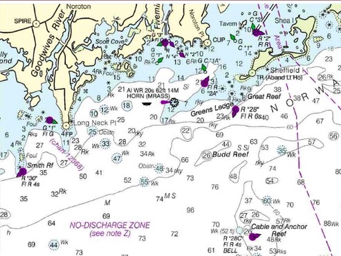
This is conjecture, but I’m guessing that the boat operator had intended to proceed to the channel marked in the upper right portion of the above chart, probably in order to get out of the weather conditions that had been encountered. If that is in fact the case, how did he miss seeing this?:
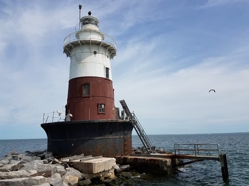
Clearly marked on the chart is this 62’ structure which marks a safe path to the channel.
A good lesson for everyone to remember is that Aids to Navigation (ATON’s) are designed to be used WITH a nautical chart. The chart will usually give a brief description of what is depicted thereon—and what you are looking at on the water. Why is that important? Because, it is sometimes difficult to distinguish by “eyeball” between a “channel” marker (such as the “2A” above) and a “coastal” marker (such as the “28” above)—when operating in unfamiliar areas.
Take the safe route! As Ranger Doug says “it may not be the shortest way, but it’s the cowboy way."
/fl