
Be careful to not “run aground" on technology
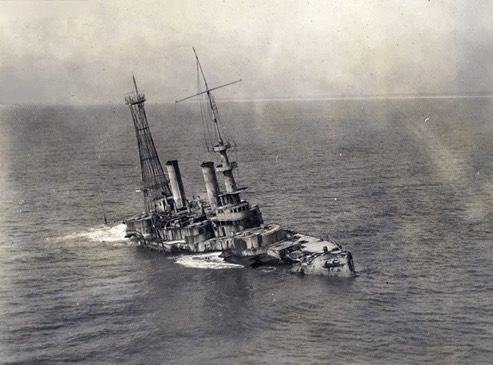
WW-1 Battleship USS Massachusetts
A recent case in point; The Coast Guard reports that "Watchstanders at Coast Guard Sector Mobile received a mayday call at 10:47 a.m. from the 50-foot Sport Fisher Slow Motion. The recreational vessel reportedly "ran aground", with all nine boaters aboard abandoning the vessel. Watchstanders diverted a 45-foot Response Boat-Medium boatcrew from Coast Guard Station Pensacola that was already patrolling the area."
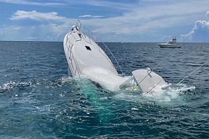
The Coast Guard rescued nine people after their vessel "ran aground" and started to take on water July 9, 2022 near Pensacola Pass, Florida. Watchstanders diverted a 45-foot Response Boat - Medium boatcrew from Coast Guard Station Pensacola to assist and all nine people were rescued with no injuries. (U.S. Coast Guard courtesy photo)
"The Pensacola boatcrew arrived on scene at 10:56 a.m., recovered all nine people out of the water and transported them back to Big Lagoon State Park in Pensacola.”
At and near the location where this boat sank, there is no water shallow enough for a sportfishing boat this size to run aground in the conventional sense, so I'm assuming that they hit the top of the sunken Battleship. Why? It was broad daylight in good weather!
I have not seen any official investigative reports concerning what the helm-watch on Slow Motion was doing, other than the boat was eastbound along the coast. They evidently didn’t know that they had hit a battleship. The wreck is not only charted, but it is a popular site for fishermen and sport divers. The wreck-site is marked with a lighted red buoy that is listed in both the Light List and on nautical charts.
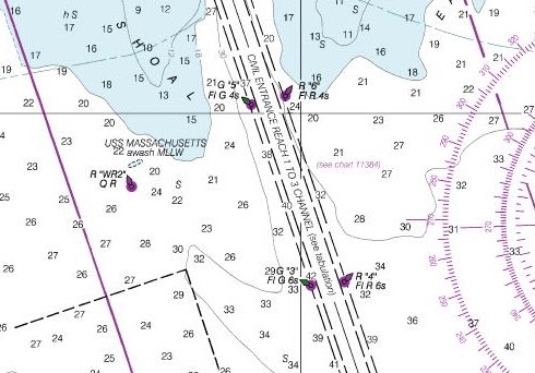
The “old style” raster chart shows it thusly:
The newer ENC chart shows a little less detail concerning the relationship of the buoy to the wreck:
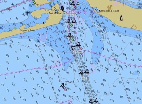
Either way, the rule is still the same; keep the coastal red buoys (and their red lights) between your boat and the shore when you are traveling offshore along the coast.
How do you discern whether a buoy is a coastal mark or a channel mark? The best answer to that question is, either with local knowledge, or by using a nautical chart. Our system of buoyage is designed to be used WITH a chart (and nowadays it doesn’t hurt to have a Light List handy)—especially when you are in unfamiliar waters.
An expensive “catch” for ’Slow Motion' that was!
Stay safe.
Click here for some history about the Battleship USS Massachusetts (BB-2).
/fl