
iPhone Radar Displays
If it weren't for the availability of three-dimensional weather radar on iPhone applications, I'd probably still be using my old cellular "flip phone." Granted, there are also other non-weather "app's" that make an iPhone extremely useful nowadays, but when you live along the coast of the Gulf of Mexico, it's comforting to have a Radar repeater clipped to your belt.
I guess that the underlying reason why this is so important to me is that I grew up in in the part of the USA known as "tornado alley." In 1948, when I was just a munchkin, we lost our home in a devastating tornado. Fifteen years later, I was operating a Radar on an Ocean Station Vessel, tracking storms and airplanes in the middle of the North Atlantic ocean. The utility and value of Radar for weather detection was firmly fixed. Later on, we made it through the 1974 Super Outbreak of tornado's (the only time in U.S. history that an entire state was under a tornado warning for 18 hours of continuous tornado activity), along with several other near misses over the years.
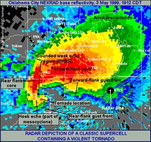
On Thursday, 9 April 1953, about five years after we lost our home in that 1948 tornado, the first recorded radar observations of a tornadic thunderstorm were made by Mr. Donald Staggs using a research radar system operated by the Illinois State Water Survey (ISWS) at Champaign. Mr. Staggs, an electrical engineer, was testing the radar that day in preparation for an upcoming field project. He recognized the intriguing nature of the echo patterns that were being detected late that afternoon and voluntarily continued the radar operations into the evening hours. Those "intriguing echo patterns" that Donald Staggs saw were the forerunner of what is now called a Tornadic Vortex Signature (TVS) by those using Doppler radar. When a TVS shows up on the screen at your local NOAA weather room, it's quite possibly the forerunner to the dreaded Hook Echo (HOOK) shown in the above illustration. And, the tornado warning will be sounded posthaste.
It's nice to have a Radar display handy!
There are several so-called "weather apps" available for the iPhone, but very few good one's. Most of them lack good radar coverage and tend to focus only on temperature and rain potential. Go for the best "real time" three-dimensional Doppler shift graphics!
One of the best free apps that I have found is WU's Storm. It has a lot of bells and whistles, but you can turn off anything that you don't need, especially the stuff that runs your battery down. It also comes with some extra-topical (non weather related) advertising that cannot be turned off, but like I said it's a free app, and the ads are incorporated in a manner that doesn't interfere too much with the display. Overall, good features and a good design. I'm not sure what the future holds for this app though. The Weather Channel purchased WU, and there have been some signs of tampering with success. If they can leave it the way it is in its current version (Spring 2017), the app is highly recommended.
I believe that the reason why we see such a difference in the quality of graphic presentations associated with the various iPhone applications is the fact that, as noted at unisys.com, there are several types of radar data available for inputing to an iPhone app., including Manually Digitized Radar (MDR), Radar Coded Messages (RCM), and (NEXt-generation RADar) NEXRAD data (NIDS). These data come from meteorological radars placed at various locations across the US. The 'Hi-Res Radar' is a composite (often referred to as a mosaic) of all NWS WSR-88D Doppler radars located throughout the continental US. Base reflectivity, in precipitation mode, is used to create this composite. The images are updated every 6 minutes.
Get a good application for your smart phone and set it up the way you like it. Then, when it comes to weather, there should be no surprises.
Happy hurricane season to all my neighbors on the Gulf Coast!
/fl