
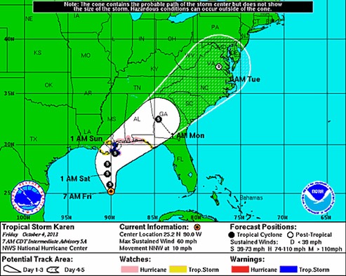
Given the spread of the guidance...the forecast of the landfall position is low confidence.
The intensity forecast is rather problematic...
We have little skill forecasting intensity, and I expect that at landfall, Karen has a 20% probability of being a Category 1 hurricane with 75 - 85 mph winds, and a 20% chance of being a minimal tropical storm with 40 - 45 mph winds. One possible scenario is a repeat of what happened with Hurricane Ida of 2009. Ida took a track very similar to Karen's, and was a hurricane with 75 mph winds just south of the mouth of the Mississippi River in Louisiana. High wind shear from an approaching trough of low pressure, combined with cooler ocean temperatures near shore, combined to cause a sudden weakening of the storm. Ida became extratropical a few hours before making landfall on the Alabama coast, and brought top sustained winds of 40 - 50 mph to the coast from Shell Beach, Louisiana to Waveland, Mississippi.