
Best Hurricane Predictor?
By Scott Jones
When the next big hurricane threatens the East Coast, maybe U.S. boaters should look to Europe when faced with decisions about whether to move their vessels or have them hauled. According to the Associated Press news agency, the European hurricane prediction model accurately predicted Hurricane Sandy’s landfall four days before the U.S. Hurricane Center got it right. In fact, the European model has proved more accurate over a three-year period.
In order to track hurricanes and predict their behavior, weather centers rely on supercomputers that can solve mathematical equations based on models.
The accuracy of different models varies however, and some frequently outperform others. In 2012, this disparity in accuracy came into the spotlight when the National Hurricane Center and the European Center for Medium-range Weather Forecasting model gave largely different projections for the path of Hurricane Sandy. (Tracks developed by the European model are often labeled with the acronym for the European Center, ECMWF.)
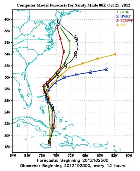
When you see a hurricane track modeling forecast, look for the initials ECMWF, acronym for the European weather center that has generated the most accurate hurricane tracks during the past three years.
Greater accuracy on the part of the European model is fairly typical. Weather Underground reports that it was the single best performing model in 2010 and 2009 when it out-performed the National Hurricane Center. In 2010, it outperformed the Hurricane Center 3-day and 4-day forecasts, and in 2009, for 4-day and 5-day forecasts. Much of the model’s spike in accuracy reportedly came from improvements made to the model in 2006.
The two main U.S. forecasting computers, one in Orlando and the other in Reston, Va., are also underpowered, according to the AP. They will receive $25 million in upgrades as part of the Hurricane Sandy supplemental bill that was recently approved by Congress. Even with the upgrade however, the European model may still be more accurate. Performance of the models in general is affected by the types and amounts of data put into the models initially. For now, the European model is still the most accurate.
A forecast using the European Model can be found here. The forecast is updated at 8 am and 8 pm EST in the summer, and at 7 am and 7 pm EST in the winter. You can also view ECMWF forecasts by going to weatherundeground.com and go WunderMap with the model layer turned on. Activate the ECMWF layer.
For 2013, NOAA has predicted an above-normal active hurricane season in the Atlantic, which start[ed] June 1 and ends on November 30. NOAA has estimated a 70 percent chance of 13-20 named storms, seven to 11 hurricanes and three to six major hurricanes. The organization does not make official predictions on the hurricane landfall outlook, but with the increased storm frequency comes an increased likelihood of landfall.
For the Eastern Pacific it predicts a 55 percent chance of having a below average season. It has estimated a 70 percent chance of 11-16 named storms, five to eight hurricanes, and one to four major hurricanes.
---
A wag of the tail to Scott Jones and PassageMaker.com