
The "Erin's"
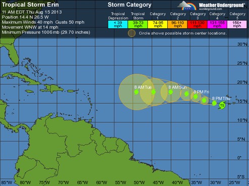
As Erin 2013 starts its journey accross the Atlantic, we can compare it to its namesakes, Erin 1995 that visited us 18 years ago, and Erin 2001.
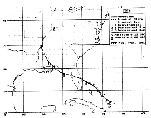
Erin (1995) formed from a tropical wave that crossed from the coast of Africa to the tropical eastern Atlantic Ocean on 22 July 1995.
On the evening of the 31st, Erin became a hurricane while centered near Rum Cay in the Bahamas.
Erin made landfall around 0600 UTC on the 2nd near Vero Beach, Florida as a Category 1 hurricane on the Saffir/Simpson Hurricane Scale, with estimated maximum one-minute wind speeds of 75 knots.
Erin's track bent back to west-northwest while the cyclone crossed the Florida peninsula during the morning and early afternoon of the 2nd. The cyclone weakened to a tropical storm with 50-knot winds during that period, but remained well-organized. Upon emerging into the eastern Gulf of Mexico, Erin reintensified on a track that gradually swung back to northwestward at about 10 knots. Final landfall occurred near Pensacola, Florida during the late morning of 03 August 1995. An eye had redeveloped but upper-level outflow was not particularly impressive on satellite images. Erin had around 85 knot winds (Category 2) in a small area of its northeastern eyewall when that part of the hurricane came ashore near Fort Walton Beach in the western Florida panhandle.
Erin 2001 took a different path.
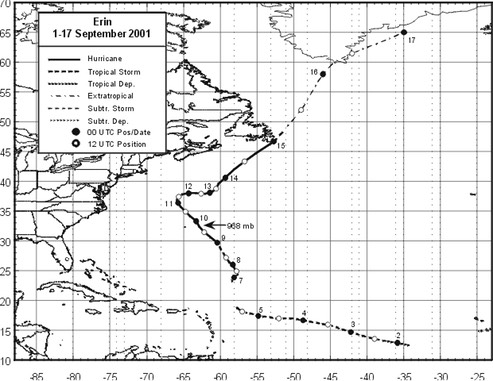
Erin (2001) can be traced back to a tropical wave that emerged from western Africa on 30 August.
By 5 September, southwesterly shear caused the tropical cyclone to degenerate into an area of disturbed weather.
About a day later, a surface circulation re-developed in the northern part of the area of disturbed weather that was associated with Erin. The re-generated tropical depression moved north-northeastward, then north-northwestward, and regained tropical storm strength about 550 n mi north-northeast of the northern Leeward Islands at 1800 UTC 7 September.
Erin strengthened into a hurricane late on the 8th. While passing east of Bermuda on the 9th, Erin continued to strengthen, and it reached its peak intensity of 105 kt around 1800 UTC that day. A few hours later, the eye of the hurricane passed within about 90 n mi east-northeast of Bermuda, which was Erin's point of closest approach to the island.
After brushing Bermuda, the hurricane continued to move mainly toward the north...
Now, we watch the travels of Erin 2013.
-fl