
Harvey rapidly strengthening
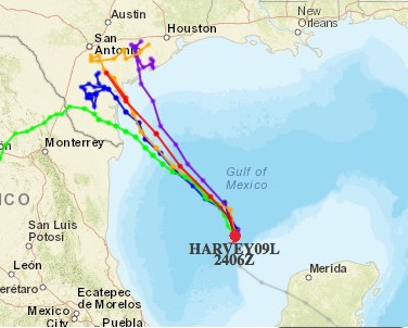
Forecasting models; the red line is the "official forecasted track."
According to Dr. Jeff Masters:
At 6:42 am CDT Thursday, an Air Force hurricane hunter plane found that Harvey had formed a partial eyewall, with a 986 mb pressure. By 8:04 am CDT, the eye had completely closed off, and the pressure had fallen another 2 mb, to 984 mb. By 10 am CDT, the pressure had fallen another 2 mb, to 982 mb. This is the central pressure that a Category 1 hurricane typically has, but the Hurricane Hunters measured top surface winds of just 65 mph. It takes up to six hours for a tropical cyclone's winds to respond to a fall in pressure, so I expect that Harvey will be a hurricane by the 4 pm CDT Thursday advisory.
Conditions in the Gulf of Mexico on Thursday morning were very favorable for intensification. Satellite images showed that Harvey was a large storm, whose high-level cirrus clouds were already spreading over extreme southern Texas. Harvey had an intense ring of heavy thunderstorms surrounding the eye, and solid low-level spiral bands were forming. The eye was just beginning to appear on both visible and infrared imagery at 10 am CDT. High cirrus clouds streaming away from the center showed the presence of upper-level outflow to the north and east, which was ventilating the storm and allowing intensification to occur. Wind shear was light, 5 – 10 knots, which is favorable for intensification. The atmosphere had a high mid-level relative humidity of 70%, and the ocean was very warm, with sea surface temperatures (SSTs) of 30.5°C (87°F.) Warm waters extended deep into the ocean, providing a large reservoir of heat for the storm to draw upon. The outer bands of Harvey are visible on Brownsville long-range radar.
Now that Harvey has a well-formed structure, I don’t see any impediments to it intensifying right up until landfall. I expect Harvey will be a Category 2 hurricane by Friday morning and a Category 3 hurricane by Friday night. Harvey probably does not have enough time to become a Category 4 storm, though we cannot rule that possibility out yet.
The current favorable conditions for development will remain in place through Friday night, according to the 12Z Thursday run of the SHIPS model. Wind shear will remain light to moderate, and the atmosphere will be moist. SSTs will remain near 30°C (86°F), and warm waters will extend to considerable depth, with a total ocean heat content of 50 – 80 kilojoules per square centimeter. From Thursday night into Friday, Harvey will get an extra boost in energy as it passes over a warm-core eddy that broke off from the Loop Current. The oceanic heat content within the eddy exceeds 75 kilojoules per square centimeter, enough to support rapid intensification. However, the heat content of this eddy is not as high as the heat content available to Hurricane Katrina of 2005, when it moved over a similar warm-core eddy.
This morning’s runs of our top intensity models—the HWRF, LGEM, COAMPS-TC, and DSHIPS—all predicted a Category 2 or 3 hurricane at landfall.
It looks like the Alamo is going to get a bath, and everyone in between had better hunker down!
/fl