
Florence
Florence has rapidly intensified into an extremely dangerous hurricane… the size of the hurricane-force winds has doubled in the past 12 hours.
None of the guidance suggest that Florence has peaked in intensity, and this is supported by a continuation of a low-shear environment, and even warmer waters over the next 36 hours. Thus, the intensity forecast is raised from the previous one, bringing Florence close to category 5 strength tomorrow. Near landfall, the vertical wind shear could increase, along with the increasing likelihood of eyewall cycles. While the intensity forecast shows some weakening of the maximum winds near landfall, the wind field is expected to grow with time, which increases the storm surge and inland wind threats. The bottom line is that there is high confidence that Florence will be a large and extremely dangerous hurricane, regardless of its exact intensity.
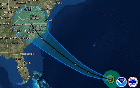
The predicted path of Hurricane Florence has the center of the storm (low) making landfall Thursday afternoon on the coast of North Carolina. Depending on the strength of the storm when it makes landfall, the surge could be 15 or more feet. Evacuation is mandatory and critical for those persons living in low lands near shore.
/fl