
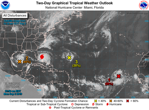
Hurricane Dorian
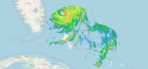
Satellite and radar imagery show that Dorian is moving very slowly over Grand Bahama Island this morning...A prolonged period of catastrophic winds and storm surge will continue to affect Grand Bahama Island through today and tonight...Dorian is forecast to remain a very powerful hurricane while it moves near the southeastern United States coast...The hurricane is expected to drift westward or west-northwestward over the next 24 hours, which will cause a prolonged period of devastating winds and storm surge over Grand Bahama Island. By late Tuesday, the weakness in the ridge becomes more pronounced and Dorian should turn northwestward near the east coast of the Florida. By day 3, the hurricane is expected to make a northeastward turn ahead of a broad mid-latitude trough. The overall track envelope has not changed much, and little adjustment to the previous NHC forecast was required...It cannot be stressed enough that only a small deviation to the left of the NHC forecast could bring the core of the extremely dangerous hurricane onshore of the Florida east coast within the hurricane warning area. In addition, Dorian's wind field is predicted to expand, which would bring hurricane-force winds closer to the east coast of Florida...Life-threatening storm surge and dangerous hurricane-force winds are expected along portions of the Florida east coast and Georgia coast, regardless of the exact track of Dorian's center.
Triple digit (100-155 mph) wind speeds are forecast through the next four days as hurricane dorian grinds away. It still looks like the center of the eye will be tracking offshore in or near the Gulf Stream.
Source: NOAA & Bahamas Radar
But wait, there’s more!
/fl