The 1-2-3 Rule
For vessels at sea, avoiding the 34 KT (knot) (39 MPH) wind field of a tropical storm is paramount. 34 KT is chosen as the critical value because as wind speed increases to this speed, sea state development approaches critical levels resulting in rapidly decreasing limits to maneuverability. It also deserves mention that the state of the sea outside of the radius of 34 KT winds can also be significant enough as to limit course & speed options available to the mariner and must also be considered when avoiding tropical storms.
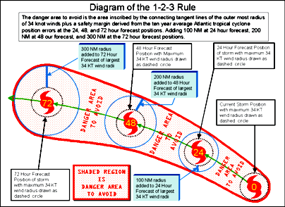
The 1-2-3 Rule is means of avoiding winds associated with a tropical cyclone by taking into account the forecast track error of the National Weather Service over a 10 year period which is approximately 100 nm in 24 hours, 200 nm for 48 hours and 300 nm in 72 hours. The forecast track error is added to the 34 knot wind radii to compute the danger area. The wind radii may be found within Tropical Cyclone Forecast Advisory (TCM) forecasts. For more detailed information on the 1-2-3 Rule, see the National Hurricane Center's Marine Safety Page
The 1-2-3 rule establishes a minimum recommended distance to maintain from a hurricane in the Atlantic. Larger buffer zones should be established in situations with higher forecast uncertainty, limited crew experience, decreased vessel handling, or other factors set by the vessel master. The rule does not account for sudden & rapid intensification of hurricanes that could result in an outward expansion of the 34 KT wind field. Also, the rule does not account for the typical expansion of the wind field as a system transitions from hurricane to extratropical gale/storm.
The National Hurricane Center and Central Pacific Hurricane Center also prepare Atlantic, East Pacific and Central Pacific "Tropical Cyclone Danger Area" charts for broadcast via radiofax, depicting the danger area computed using the 1-2-3 Rule as a basis. The danger area will not be depicted for tropical cyclones that transition to extratropical status.