
Eta
Tropical Depression Eta
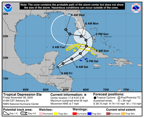
Discussion Number 24 NWS National Hurricane Center Miami FL AL292020 900 AM CST Fri Nov 06 2020
Satellite imagery indicates that Eta is producing organized convection in a large band over its northern and eastern quadrants, with the center located just off the coast of Belize near the western end of the band. These data, along with surface observations, also show that the circulation is elongated. The initial intensity remains 30 kt in agreement with a satellite intensity estimate from TAFB. An Air Force Reserve Hurricane Hunter aircraft is scheduled to investigate Eta this afternoon, and a NOAA flight is scheduled for this evening.
The initial motion is a somewhat uncertain 025/6 kt. A developing mid- to upper-level trough over the Gulf of Mexico is expected to steer Eta northeastward for the next 48 h or so with an increase in forward speed. Between 48-72 h, the trough is forecast to become a closed low near south Florida and western Cuba, with Eta expected to turn northwestward around and into the low. After 72 h, the merged system is likely to move slowly west-northwestward. While the guidance is in good agreement on the synoptic evolution, there are a lot of differences in the track forecast details in terms of both the heading and the forward speed, with the GFS-based guidance tending to be to the east and north of the UKMET/ECMWF/Canadian. Overall, the consensus models have shifted a little to the east and north since the last advisory, and the new forecast track is also nudged in those directions.
Eta will move over the warm waters of the northwestern Caribbean during the next 48 h or so, and the upper-level divergence is forecast to be quite strong. This should allow some strengthening, although this is likely to be slowed by 20-30 kt of southwesterly vertical wind shear. The intensity forecast for this part of the cyclone's life is similar to the previous forecast and lies a bit below the bulk of the intensity guidance. Between 48-72 h , Eta may take on at least some subtropical cyclone characteristics as it merges with the mid- to upper-level low. During this process, some of the guidance suggests the possibility that a tight inner wind core may develop. There is a chance that during this time that Eta could regain hurricane strength, although this would be an intensity above the current guidance. After 72 h, dry air entrainment is expected to cause the cyclone to weaken.
The wind field of Eta is expected to increase in size during the next few days, and the cyclone will likely produce a large area of tropical-storm-force winds on its north side when it is near Cuba, the Florida Keys, and southern Florida.
The new forecast track requires a Tropical Storm Warning for the Cayman Islands at this time, and a Tropical Storm Watch for portions of Cuba. Watches may be required for portions of south Florida and the Florida Keys later today or tonight.
/NOAA
As Yogi said, “It ain’t over ‘till it’s over!”
/fl